

The Great Lakes have many effects on regional climate, and ice cover on the lakes is an important factor in determining climate patterns.
So, how much ice is sitting on top of the Great Lakes, and what impact will that ice cover have in the upcoming months?
Maximum ice cover on the Great Lakes typically occurs between mid-February and early March. As we approach our seasonal maximum for ice cover, we're seeing a fair amount of ice observed on each lake, with total ice coverage on all the lakes at 42.2%.
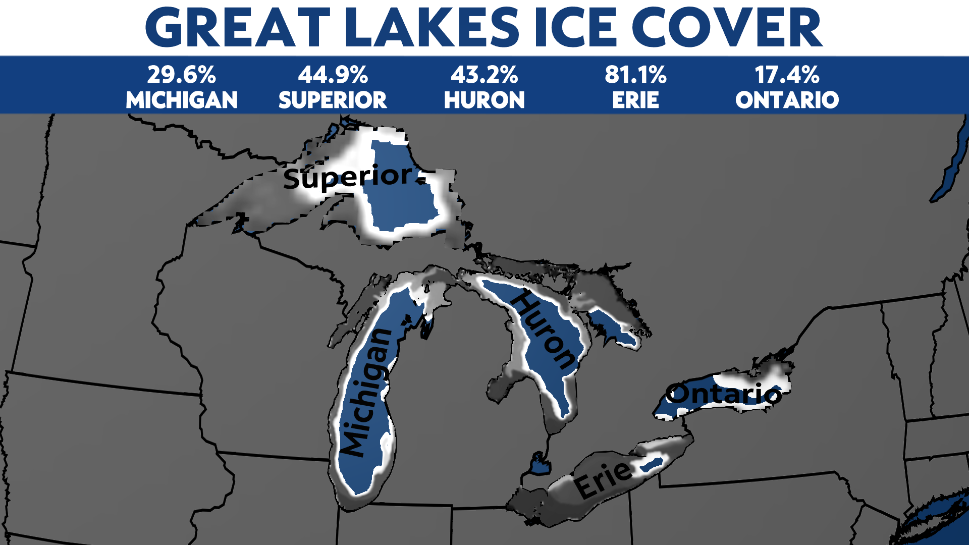
On average, our maximum ice cover for the season is 53.3%. Although our ice coverage on the lakes has been increasing, it is still considered low for this time of year.
Where are each of the lakes compared to the average, and how does this year compare to years past?
Ice coverage on Lake Michigan and Lake Superior is slightly above average for this time of year. Lake Erie is significantly higher than its average of 66.0%, with a total ice cover of 81.1%.
We can credit the recent string of bitterly cold arctic temperatures for the increased ice growth on the lakes. Although it has increased the ice coverage on 3 of the 5 Great Lakes, Lake Huron and Lake Ontario are still slightly below their seasonal averages.
Ice growth was slow to start thanks to unseasonably warm temperatures across the Great Lakes states in December. Much of the major freezing happens in February, so there is still some time for additional ice growth.

The ice cover on each of the 5 Great Lakes is significantly higher than it was at this time last year. 29.6% of Lake Michigan is covered with ice, compared to just 13.7% at this time last year.
Lake Superior's ice cover was just 12.3% at this time last year but is currently sitting at 44.9%. The most impressive statistic is Lake Erie, which is 81.1% covered with ice, while last year had just 3.2% ice coverage.
Overall, ice coverage is comparable to 2019 on Lake Michigan, Lake Huron, and Lake Erie. It was much higher on Lake Superior in 2019 as record-cold temperatures moved into the region, allowing for rapid ice growth on the lake.

As the lakes freeze in the winter, our lake-effect snow events tend to subside. Lake-effect snow forms as cold air moves over a relatively warm lake. More ice on the lakes means less unfrozen water. When there is no moisture available to be carried into the atmosphere, lake-effect snow can't develop.
The amount of ice on the lakes can also impact lake temperatures later in the year. More ice typically means cooler lake temperatures during the spring and summer months since the ice first needs to melt before the water below can start to warm.