We've been hearing a lot about La Niña in recent weeks, but what exactly is a La Niña and how will it impact our upcoming winter in Wisconsin?
In order to understand the effects of La Niña on the winter weather pattern in Wisconsin, we first need a basic understanding of what La Niña is and what causes it.
La Niña, in general, refers to colder-than-normal ocean water temperatures in the equatorial Pacific. It's caused by an interaction between the ocean water and the atmosphere. During episodes of La Niña, strong trade winds push warm ocean water east to west across the Pacific Ocean, causing cold water to rise to the surface off the west coast of North and South America.
This upwelling pushes the polar jet stream to the north, which affects how and where storms develop and the impact they have on the United States.
In a typical La Niña winter, the overall winter weather pattern looks like this:
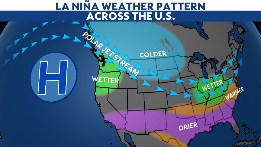
During La Niña winters, cold, arctic air is more likely to dive into the western Great Lakes region, leading to a higher chance of below-normal temperatures during the winter months.
A recent study by the National Weather Service in Green Bay looked at 22 La Niña winters since 1950 and found that average temperatures for 11 of the 22 winters were below normal, eight winters were above normal and three winters were near normal. This supports the idea of colder temperatures impacting Wisconsin during episodes of La Niña.
The same study found a 77% chance of near or above-normal precipitation during La Niña.
Based on past events, there is a 68% chance of above-normal snowfall for the entire season, which runs from October to May. Some of our snowiest winters across Wisconsin occurred during La Niña winters.
Although the potential for higher snowfall amounts looks more likely to occur this winter, that is not always the case, since snowfall amounts can be highly variable across the state.
In general, Wisconsin tends to be impacted more by individual snowstorms compared to larger-scale weather patterns in the winter. A handful of powerful storms will be all it takes for cities in Wisconsin to reach or surpass their average winter snow totals.

The latest projections from the Climate Prediction Center suggest the average temperature from December through February may be near normal or have slightly higher odds of being above normal.
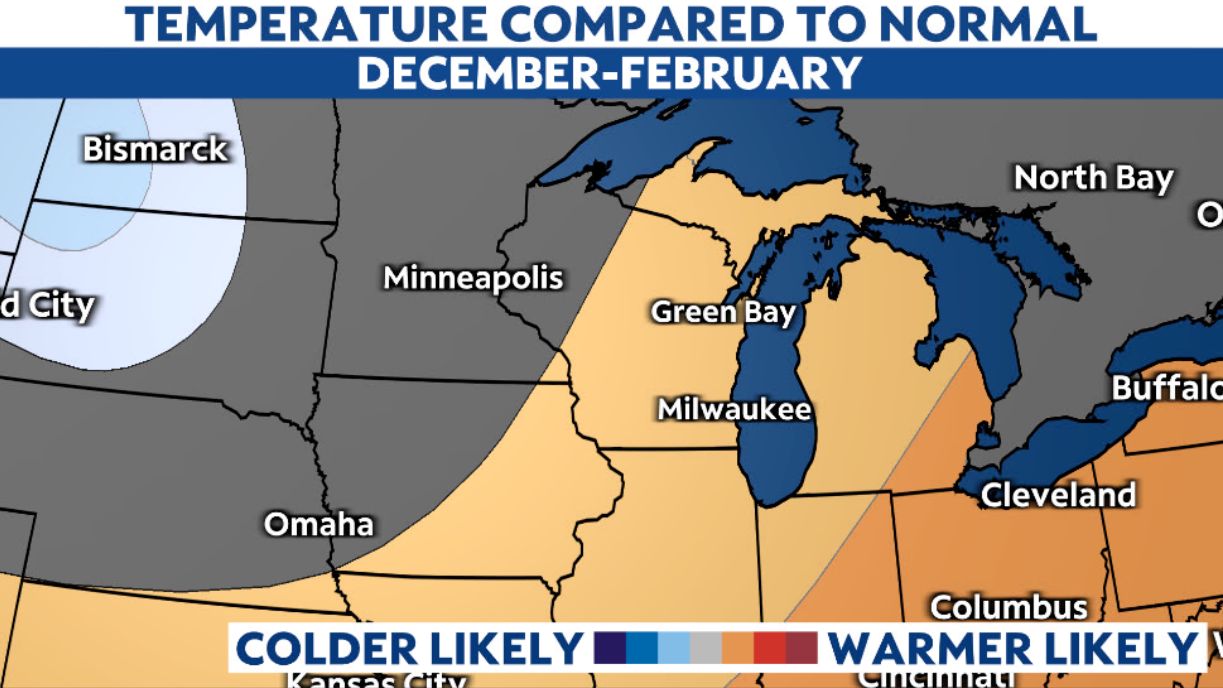
During that same timeframe, odds are for near-normal precipitation with a lean toward above-normal.

As we crunch the numbers and make sense of all the data as we head into the winter season, and with La Niña conditions being observed in the Pacific, it is more than reasonable to say that Wisconsin will likely see snowfall totals near to above average this winter.
Temperatures are likely to follow suit with brief periods of arctic air intruding into the state, but a few warmer spells are also possible.
After last winter's lackluster snowfall in many areas across Wisconsin, the potential to reach our seasonal norm may be welcome this winter!