


Let’s ring in the New Year by looking back at the top five weather events across Ohio in 2022. These were the most significant weather events of the year with the greatest impact.
We’ll start with weather event 5 and countdown to the most extreme weather event of 2022!
Happening overnight as a cold front swept across the state, high winds caused widespread damage and power outages.
On March 30, the air was extremely dry with low humidity with warm temperatures. Plus, there was an elevated fire threat as a strong southerly wind picked up ahead of the front.
Temperatures would drop from the 60s to the 30s by March 31 and by April 1st it was cold enough for wrap around snow showers on the back side of the system.
However, the highlight of the event was the high winds overnight March 30, which took power poles and tree limbs down. Gusts throughout the state topped out at 40 to 50 mph.
The strongest wind gust was at the Cincinnati Lunken airport at 69 mph! This is unusual because a thunderstorm did not produce this gust of wind.
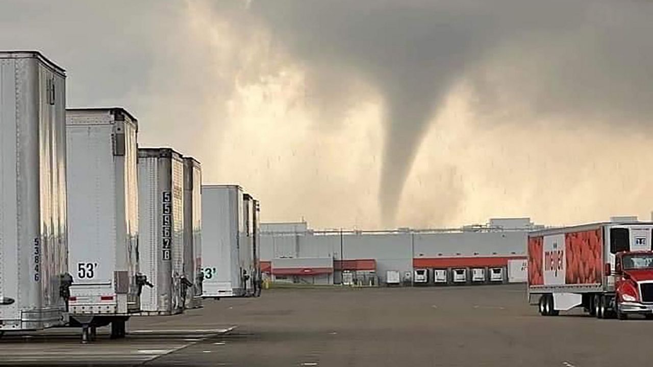
On June 8, a round of severe weather produced 6 confirmed tornadoes across parts of the state.
An EF-2 tornado passed through West Milton and Tipp City and its surrounding areas. It was on the ground for nearly 14 miles, with the greatest damage coming to a Meijer distribution center. One exterior wall collapsed, and the building had extensive roof damage.
Two EF-1 tornadoes went through Drake and Clark counties. One in southeastern Darke County damaged farm buildings during its 2.5 mile track. The other one struck the Springfield area in Clark County, snapping and uprooting trees and damaging buildings on its 17-mile path.
The two EF-0 tornadoes caused tree damage. One tracked north of Urbana in Champaign County, while another moved through Sardinia in Brown County.
The sixth confirmed tornado occurred in Hocking County.
An early February snow storm is typical in Ohio, but this winter storm was one for the record books!
Starting Feb. 3, a massive winter storm set up across the Midwest, but the worst of the event hit the Ohio valley with a combination of rain, freezing rain, sleet and snow.
It was impossible to travel by Feb. 4 with the heaviest snow in northern Ohio and most of the ice farther south.
Snowfall totals in northwestern Ohio were about a foot! Central and southern Ohio had more sleet and freezing rain with a top layer of snow.
According to the NWS Wilmington, cities like Dayton broke snowfall records!
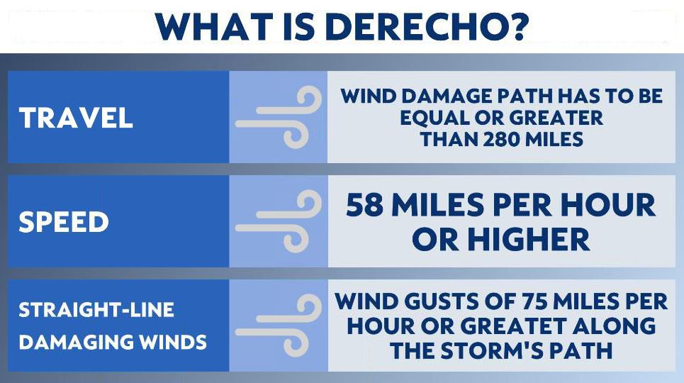
A powerful cluster of thunderstorms known as a derecho moved through the northern and eastern Ohio mid June. A derecho, according to the NWS, is defined as, “a widespread, convectively induced straight-line windstorm, more specifically, any family of downburst clusters produced by an extratropical mesoscale convective system.”
This severe line of thunderstorms must meet the following criteria in order to be classified as a derecho: traveling 250 to 400 miles in length, having 60 miles in width, and containing winds of 58 mph or greater with additional greater wind gusts of 75 mph or more.
On June 13, a derecho in Michigan and Indiana tracked into NW Ohio in the evening. The line of storms quickly moved into NE and E Ohio into the night.
Estimated winds of 60 to 70 mph from northwest Ohio to northeastern Ohio.
There was extensive damage from Richland, Ashland, and Morrow Counties through Holmes, and Knox, according to the NWS office in Cleveland, widespread tree damage from winds likely up to 80 mph. It took several days to clean up the damage.
In additional to the straight-line winds, there were three confirmed EF-1 tornadoes. One of the tornadoes had maximum winds of 105 mph, which touched down in Chesterville and ended 5 miles outside of Fredericktown.
Finally, a major winter storm for the ages hit the Ohio valley leading up to Christmas 2022.
A high-impact, multi-hazard winter storm halted holiday travel, broke records, and brought extreme cold to the Ohio valley.
This impressive storm began Thursday night as rain quickly changed to snow. Temperatures Thursday hit the 40s then fell to near 0 early Friday morning, not including wind chills.
Wind chills throughout the day Friday were once in a generation cold as low as -30 to -35 degrees! Dangerously cold wind chills lasted well into Saturday, and didn’t reach above 0 until Sunday, Christmas Day for many parts of the state.
Not only did this winter storm bring extreme cold, but also high winds and snow. The combination of the two caused white out conditions Friday and Saturday with blowing and drifting snow.
With a ‘flash freeze’ early Friday as the ground iced over with accumulating snow on top, roads were treacherous to drive on with extremely low visibility.
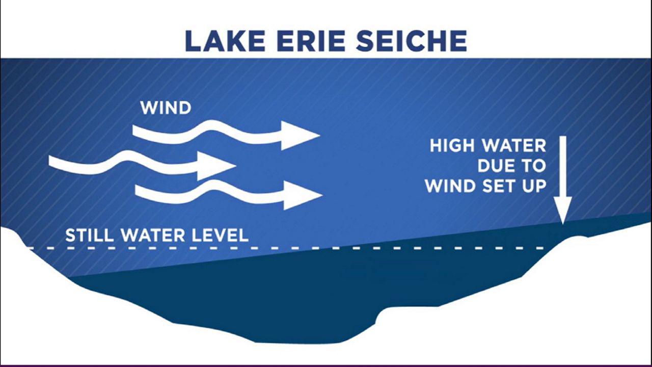
Wind gusts through the day Friday topped off around 40 to 50 mph, but there were stronger wind gusts along the Lake Erie shoreline that pushed 75 mph! That’s hurricane-force winds!
Due to the hurricane force winds gusts across Lake Erie, another rare event occurred, a seiche. This caused water to be shifted toward upstate New York while causing the water to empty near Toledo and along northern Ohio.
For the first time in ten years, Cleveland and surrounding northeast Ohio Counties were issued a Blizzard Warning. The last time his happened was back in 2012.
The Cincinnati airport, located in northern Kentucky, officially reached Blizzard standards from 1230 am to 4 am Friday morning with sustained winds over 35+ mph, and visibility under a ¼ of a mile for over three hours!
Our team of meteorologists dives deep into the science of weather and breaks down timely weather data and information. To view more weather and climate stories, check out our weather blogs section.