FLOODING
Kentucky historian recounts recent flood’s historical context
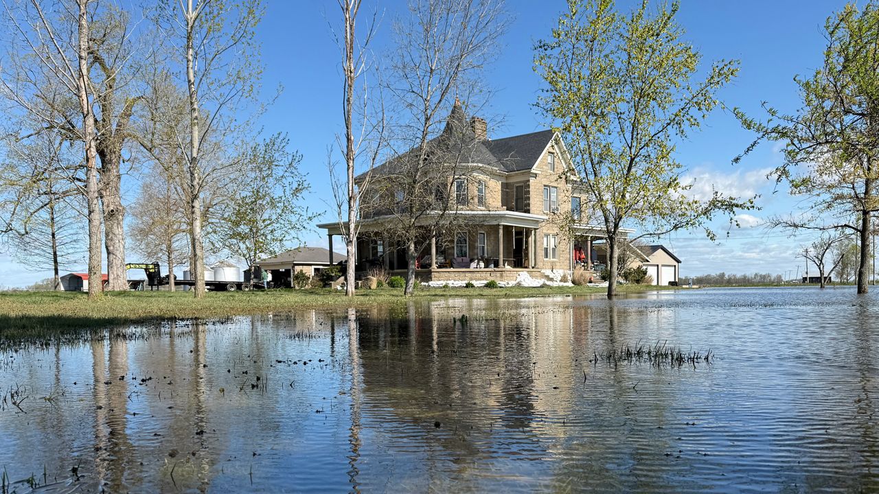
Grady Ebelhar said the latest flood didn’t reach the heights of 1937.
2:17
Active Weather Alerts for Bowling Green, KY
| Location | Alert Type |
|---|---|
| Ohio County 04/23/2025 9:51 AM | Flood Warning Details |
| ...The Flood Warning continues for the following rivers in Kentucky... Rough River near Dundee affecting Ohio County. * WHAT...Minor flooding is occurring and minor flooding is forecast. * WHERE...Rough River near Dundee. * WHEN...Until further notice. * IMPACTS...At 25.0 feet, County roads between Dundee and Narrows flood. At 26.0 feet, County roads near Sunnydale flood. At 27.0 feet, KY 919 flood at Underwood and Clifty Huff Roads near Narrows. * ADDITIONAL DETAILS... - At 8:00 AM CDT Wednesday the stage was 26.4 feet. - Bankfull stage is 23.0 feet. - Recent Activity...The maximum river stage in the 24 hours ending at 8:00 AM CDT Wednesday was 26.6 feet. - Forecast...The river is expected to fall to 25.7 feet Monday morning. - Flood stage is 25.0 feet. - Flood History...No available flood history. - http://www.weather.gov/safety/flood PRECAUTIONARY/PREPAREDNESS ACTIONS... Motorists should not attempt to drive around barricades or drive cars through flooded areas. Turn around, don't drown when encountering flooded roads. Most flood deaths occur in vehicles. Flooding is occurring or is imminent. Most flood related deaths occur in automobiles. Do not attempt to cross water covered bridges, dips, or low water crossings. Never try to cross a flowing stream, even a small one, on foot. To escape rising water find another route over higher ground. Additional INFO is available at www.weather.gov/lmk. The next statement will be issued by Thursday afternoon at 145 PM CDT. LAT...LON 3755 8649 3743 8694 3743 8710 3752 8713 3751 8696 3766 8653 3755 8649 | |
| Ohio County 04/19/2025 8:00 PM | Flood Warning Details |
| ...The Flood Warning continues for the following rivers in Kentucky... Green River at Rochester affecting Muhlenberg, Ohio and Butler Counties. * WHAT...Minor flooding is occurring and minor flooding is forecast. * WHERE...Green River at Rochester. * WHEN...Until Saturday evening. * IMPACTS...At 34.0 feet, Rochester Ferry stops operation. At 37.0 feet, Reeds and Rochester Ferries remain closed. KY 369 floods one mile north of Rochester. * ADDITIONAL DETAILS... - At 7:45 AM CDT Wednesday the stage was 42.2 feet. - Bankfull stage is 34.0 feet. - Recent Activity...The maximum river stage in the 24 hours ending at 7:45 AM CDT Wednesday was 44.2 feet. - Forecast...The river is expected to fall below flood stage early Saturday afternoon and continue falling to 34.9 feet Monday morning. - Flood stage is 37.0 feet. - Flood History...No available flood history. - http://www.weather.gov/safety/flood PRECAUTIONARY/PREPAREDNESS ACTIONS... Motorists should not attempt to drive around barricades or drive cars through flooded areas. Turn around, don't drown when encountering flooded roads. Most flood deaths occur in vehicles. Flooding is occurring or is imminent. Most flood related deaths occur in automobiles. Do not attempt to cross water covered bridges, dips, or low water crossings. Never try to cross a flowing stream, even a small one, on foot. To escape rising water find another route over higher ground. Additional INFO is available at www.weather.gov/lmk. The next statement will be issued by Thursday afternoon at 100 PM CDT. LAT...LON 3728 8680 3718 8690 3727 8697 3739 8678 3728 8680 | |
| McLean County 04/23/2025 9:06 PM | Flood Warning Details |
| ...The Flood Warning continues for the following rivers in Kentucky... Green River at Paradise and Calhoun. .Levels on the Green River will continue to fall, but will remain above flood stage at Paradise and Calhoun into next week. * WHAT...Major flooding is occurring and major flooding is forecast. * WHERE...Green River at Calhoun. * WHEN...Until further notice. * ADDITIONAL DETAILS... - At 7:00 PM CDT Wednesday the stage was 34.8 feet. - Forecast...The river is expected to fall to 27.7 feet Monday evening. - Flood stage is 23.0 feet. - http://www.weather.gov/safety/flood PRECAUTIONARY/PREPAREDNESS ACTIONS... Caution is urged when walking near riverbanks. Additional INFO is available at www.weather.gov. LAT...LON 3775 8742 3772 8730 3763 8739 3751 8703 3743 8707 3761 8757 3775 8742 | |
| Webster County 04/23/2025 9:06 PM | Flood Warning Details |
| ...The Flood Warning continues for the following rivers in Kentucky... Green River at Paradise and Calhoun. .Levels on the Green River will continue to fall, but will remain above flood stage at Paradise and Calhoun into next week. * WHAT...Major flooding is occurring and major flooding is forecast. * WHERE...Green River at Calhoun. * WHEN...Until further notice. * ADDITIONAL DETAILS... - At 7:00 PM CDT Wednesday the stage was 34.8 feet. - Forecast...The river is expected to fall to 27.7 feet Monday evening. - Flood stage is 23.0 feet. - http://www.weather.gov/safety/flood PRECAUTIONARY/PREPAREDNESS ACTIONS... Caution is urged when walking near riverbanks. Additional INFO is available at www.weather.gov. LAT...LON 3775 8742 3772 8730 3763 8739 3751 8703 3743 8707 3761 8757 3775 8742 | |
| Daviess County 04/18/2025 6:30 AM | Flood Warning Details |
| ...The Flood Warning is extended for the following rivers in Indiana...Kentucky... Ohio River at Newburgh Dam, Evansville, Henderson, Mount Vernon, J.T. Myers Dam, Shawneetown and Golconda. .Levels on the Ohio River will continue to drop, falling below flood stage at Evansville late tonight, at Newburgh and Henderson Thursday night, and at points from Mount Vernon to Golconda Sunday or Monday. * WHAT...Minor flooding is occurring and minor flooding is forecast. * WHERE...Ohio River at Newburgh Dam. * WHEN...Until early Friday morning. * ADDITIONAL DETAILS... - At 8:00 PM CDT Wednesday the stage was 43.6 feet. - Forecast...The river is expected to fall below flood stage late tomorrow evening. - Flood stage is 38.0 feet. - http://www.weather.gov/safety/flood PRECAUTIONARY/PREPAREDNESS ACTIONS... Caution is urged when walking near riverbanks. Additional INFO is available at www.weather.gov. LAT...LON 3801 8745 3790 8721 3780 8728 3787 8745 3801 8745 | |
| Henderson County 04/18/2025 6:30 AM | Flood Warning Details |
| ...The Flood Warning is extended for the following rivers in Indiana...Kentucky... Ohio River at Newburgh Dam, Evansville, Henderson, Mount Vernon, J.T. Myers Dam, Shawneetown and Golconda. .Levels on the Ohio River will continue to drop, falling below flood stage at Evansville late tonight, at Newburgh and Henderson Thursday night, and at points from Mount Vernon to Golconda Sunday or Monday. * WHAT...Minor flooding is occurring and minor flooding is forecast. * WHERE...Ohio River at Newburgh Dam. * WHEN...Until early Friday morning. * ADDITIONAL DETAILS... - At 8:00 PM CDT Wednesday the stage was 43.6 feet. - Forecast...The river is expected to fall below flood stage late tomorrow evening. - Flood stage is 38.0 feet. - http://www.weather.gov/safety/flood PRECAUTIONARY/PREPAREDNESS ACTIONS... Caution is urged when walking near riverbanks. Additional INFO is available at www.weather.gov. LAT...LON 3801 8745 3790 8721 3780 8728 3787 8745 3801 8745 | |
| Union County 04/21/2025 11:41 AM | Flood Warning Details |
| ...The Flood Warning is extended for the following rivers in Indiana...Kentucky... Ohio River at Newburgh Dam, Evansville, Henderson, Mount Vernon, J.T. Myers Dam, Shawneetown and Golconda. .Levels on the Ohio River will continue to drop, falling below flood stage at Evansville late tonight, at Newburgh and Henderson Thursday night, and at points from Mount Vernon to Golconda Sunday or Monday. * WHAT...Moderate flooding is occurring and moderate flooding is forecast. * WHERE...Ohio River at Shawneetown. * WHEN...Until late Monday morning. * ADDITIONAL DETAILS... - At 7:30 PM CDT Wednesday the stage was 52.0 feet. - Forecast...The river is expected to fall below flood stage early Monday morning. - Flood stage is 33.0 feet. - http://www.weather.gov/safety/flood PRECAUTIONARY/PREPAREDNESS ACTIONS... Caution is urged when walking near riverbanks. Additional INFO is available at www.weather.gov. LAT...LON 3778 8811 3773 8800 3757 8800 3753 8818 3771 8821 3778 8811 | |
| Fulton County 04/23/2025 10:46 PM | Flood Warning Details |
| ...The Flood Warning continues for the following rivers in Kentucky...Illinois...Missouri... Ohio River at Smithland Dam, Paducah, Olmsted Lock and Dam and Cairo. .Levels on the Ohio River from Smithland to Cairo are either cresting tonight, or are nearly steady and will begin to fall Thursday into Friday. * WHAT...Moderate flooding is occurring and moderate flooding is forecast. * WHERE...Ohio River at Cairo. * WHEN...Until Wednesday, April 23. * ADDITIONAL DETAILS... - At 7:00 PM CDT Wednesday the stage was 52.0 feet. - Forecast...The river is expected to fall below flood stage Wednesday, April 23. - Flood stage is 40.0 feet. - http://www.weather.gov/safety/flood PRECAUTIONARY/PREPAREDNESS ACTIONS... Caution is urged when walking near riverbanks. Additional INFO is available at www.weather.gov. LAT...LON 3709 8946 3717 8916 3709 8907 3680 8900 3664 8908 3671 8929 3709 8946 | |
| Henderson County 04/20/2025 11:31 AM | Flood Warning Details |
| ...The Flood Warning is extended for the following rivers in Indiana...Kentucky... Ohio River at Newburgh Dam, Evansville, Henderson, Mount Vernon, J.T. Myers Dam, Shawneetown and Golconda. .Levels on the Ohio River will continue to drop, falling below flood stage at Evansville late tonight, at Newburgh and Henderson Thursday night, and at points from Mount Vernon to Golconda Sunday or Monday. * WHAT...Moderate flooding is occurring and moderate flooding is forecast. * WHERE...Ohio River at Mount Vernon. * WHEN...Until late Sunday morning. * ADDITIONAL DETAILS... - At 6:00 AM CDT Wednesday the stage was 48.5 feet. - Forecast...The river is expected to fall below flood stage early Sunday morning. - Flood stage is 35.0 feet. - http://www.weather.gov/safety/flood PRECAUTIONARY/PREPAREDNESS ACTIONS... Caution is urged when walking near riverbanks. Additional INFO is available at www.weather.gov. LAT...LON 3792 8796 3797 8786 3794 8783 3791 8782 3780 8784 3792 8796 | |
| Union County 04/20/2025 11:31 AM | Flood Warning Details |
| ...The Flood Warning is extended for the following rivers in Indiana...Kentucky... Ohio River at Newburgh Dam, Evansville, Henderson, Mount Vernon, J.T. Myers Dam, Shawneetown and Golconda. .Levels on the Ohio River will continue to drop, falling below flood stage at Evansville late tonight, at Newburgh and Henderson Thursday night, and at points from Mount Vernon to Golconda Sunday or Monday. * WHAT...Moderate flooding is occurring and moderate flooding is forecast. * WHERE...Ohio River at Mount Vernon. * WHEN...Until late Sunday morning. * ADDITIONAL DETAILS... - At 6:00 AM CDT Wednesday the stage was 48.5 feet. - Forecast...The river is expected to fall below flood stage early Sunday morning. - Flood stage is 35.0 feet. - http://www.weather.gov/safety/flood PRECAUTIONARY/PREPAREDNESS ACTIONS... Caution is urged when walking near riverbanks. Additional INFO is available at www.weather.gov. LAT...LON 3792 8796 3797 8786 3794 8783 3791 8782 3780 8784 3792 8796 | |
| Union County 04/20/2025 11:00 PM | Flood Warning Details |
| ...The Flood Warning is extended for the following rivers in Indiana...Kentucky... Ohio River at Newburgh Dam, Evansville, Henderson, Mount Vernon, J.T. Myers Dam, Shawneetown and Golconda. .Levels on the Ohio River will continue to drop, falling below flood stage at Evansville late tonight, at Newburgh and Henderson Thursday night, and at points from Mount Vernon to Golconda Sunday or Monday. * WHAT...Moderate flooding is occurring and moderate flooding is forecast. * WHERE...Ohio River at J.T. Myers Dam. * WHEN...Until late Sunday evening. * ADDITIONAL DETAILS... - At 8:00 PM CDT Wednesday the stage was 52.2 feet. - Forecast...The river is expected to fall below flood stage Sunday afternoon. - Flood stage is 37.0 feet. - http://www.weather.gov/safety/flood PRECAUTIONARY/PREPAREDNESS ACTIONS... Caution is urged when walking near riverbanks. Additional INFO is available at www.weather.gov. LAT...LON 3778 8811 3792 8796 3780 8784 3773 8800 3778 8811 | |
| Fulton County 04/24/2025 3:23 AM | Flood Warning Details |
| ...The Flood Warning continues for the following rivers in Kentucky...Missouri... Mississippi River at at Hickman and New Madrid. .The Mississippi River at Hickman and New Madrid is cresting tonight, and will fall below flood stage at both locations next Wednesday. * WHAT...Major flooding is occurring and major flooding is forecast. * WHERE...Mississippi River near Hickman. * WHEN...Until Thursday, April 24. * ADDITIONAL DETAILS... - At 8:00 PM CDT Wednesday the stage was 45.2 feet. - Forecast...The river is currently cresting near 45.4 feet tonight. It will then fall below flood stage Wednesday, April 23. - Flood stage is 34.0 feet. - http://www.weather.gov/safety/flood PRECAUTIONARY/PREPAREDNESS ACTIONS... Caution is urged when walking near riverbanks. Additional INFO is available at www.weather.gov. LAT...LON 3669 8935 3671 8929 3664 8908 3654 8918 3654 8935 3669 8935 | |
| Henderson County 04/18/2025 3:12 AM | Flood Warning Details |
| ...The Flood Warning is extended for the following rivers in Indiana...Kentucky... Ohio River at Newburgh Dam, Evansville, Henderson, Mount Vernon, J.T. Myers Dam, Shawneetown and Golconda. .Levels on the Ohio River will continue to drop, falling below flood stage at Evansville late tonight, at Newburgh and Henderson Thursday night, and at points from Mount Vernon to Golconda Sunday or Monday. * WHAT...Minor flooding is occurring and minor flooding is forecast. * WHERE...Ohio River near Henderson. * WHEN...Until early Friday morning. * ADDITIONAL DETAILS... - At 7:45 PM CDT Wednesday the stage was 39.0 feet. - Forecast...The river is expected to fall below flood stage tomorrow evening. - Flood stage is 36.0 feet. - http://www.weather.gov/safety/flood PRECAUTIONARY/PREPAREDNESS ACTIONS... Caution is urged when walking near riverbanks. Additional INFO is available at www.weather.gov. LAT...LON 3791 8782 3793 8767 3795 8764 3785 8749 3777 8766 3780 8784 3791 8782 | |
| Daviess County 04/17/2025 5:53 AM | Flood Warning Details |
| ...The Flood Warning is extended for the following rivers in Indiana...Kentucky... Ohio River at Newburgh Dam, Evansville, Henderson, Mount Vernon, J.T. Myers Dam, Shawneetown and Golconda. .Levels on the Ohio River will continue to drop, falling below flood stage at Evansville late tonight, at Newburgh and Henderson Thursday night, and at points from Mount Vernon to Golconda Sunday or Monday. * WHAT...Minor flooding is occurring. * WHERE...Ohio River at Evansville. * WHEN...Until late tonight. * ADDITIONAL DETAILS... - At 8:00 PM CDT Wednesday the stage was 42.4 feet. - Forecast...The river is expected to fall below flood stage late tonight. - Flood stage is 42.0 feet. - http://www.weather.gov/safety/flood PRECAUTIONARY/PREPAREDNESS ACTIONS... Caution is urged when walking near riverbanks. Additional INFO is available at www.weather.gov. LAT...LON 3795 8764 3802 8759 3801 8745 3788 8745 3785 8749 3795 8764 | |
| Henderson County 04/17/2025 5:53 AM | Flood Warning Details |
| ...The Flood Warning is extended for the following rivers in Indiana...Kentucky... Ohio River at Newburgh Dam, Evansville, Henderson, Mount Vernon, J.T. Myers Dam, Shawneetown and Golconda. .Levels on the Ohio River will continue to drop, falling below flood stage at Evansville late tonight, at Newburgh and Henderson Thursday night, and at points from Mount Vernon to Golconda Sunday or Monday. * WHAT...Minor flooding is occurring. * WHERE...Ohio River at Evansville. * WHEN...Until late tonight. * ADDITIONAL DETAILS... - At 8:00 PM CDT Wednesday the stage was 42.4 feet. - Forecast...The river is expected to fall below flood stage late tonight. - Flood stage is 42.0 feet. - http://www.weather.gov/safety/flood PRECAUTIONARY/PREPAREDNESS ACTIONS... Caution is urged when walking near riverbanks. Additional INFO is available at www.weather.gov. LAT...LON 3795 8764 3802 8759 3801 8745 3788 8745 3785 8749 3795 8764 | |
| Fulton County 04/23/2025 12:12 PM | Flood Warning Details |
| ...The Flood Warning continues for the following rivers in Kentucky...Missouri... Mississippi River at at Hickman and New Madrid. .The Mississippi River at Hickman and New Madrid is cresting tonight, and will fall below flood stage at both locations next Wednesday. * WHAT...Minor flooding is occurring and minor flooding is forecast. * WHERE...Mississippi River at New Madrid. * WHEN...Until Wednesday, April 23. * ADDITIONAL DETAILS... - At 8:00 PM CDT Wednesday the stage was 39.6 feet. - Forecast...The river is currently cresting near 39.8 feet tonight. It will then fall below flood stage Wednesday, April 23. - Flood stage is 34.0 feet. - http://www.weather.gov/safety/flood PRECAUTIONARY/PREPAREDNESS ACTIONS... Caution is urged when walking near riverbanks. Additional INFO is available at www.weather.gov. LAT...LON 3662 8962 3670 8935 3654 8935 3650 8935 3648 8935 3648 8964 3662 8962 | |
Grady Ebelhar said the latest flood didn’t reach the heights of 1937.
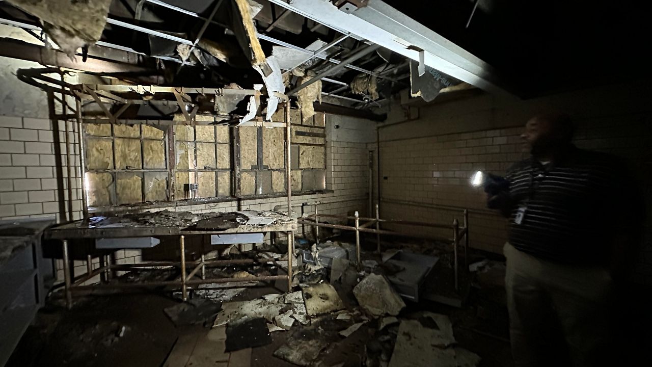
For Phase 1, Men 2 Be is hoping to use the building as a tornado shelter, a recreation center and office spaces for their mission.
Louisville Metro Police Chief Paul Humphrey shared positive data related to homicides, shootings and robberies.
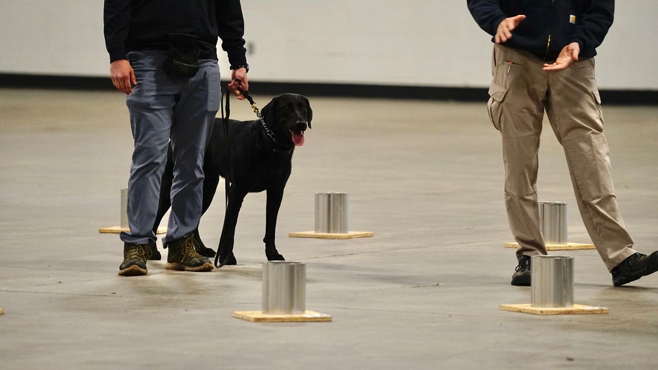
Over 30 local, state and federal teams are participating in the three-day training and evaluation session.

BourbonVille is a bourbon tasting that not only features the state's signature spirit, but will also highlight a Kentucky Proud memu.

The long annual journey northward continues for the Ruby-Throated Hummingbirds.