


As we head further into fall, changes in the weather often become more noticeable. The month of November can bring many different types of weather and patterns to Ohio.
Historical records of temperatures and precipitation are the backbone of our weather “averages” or “normals” for a particular place and date.
Here in Ohio, our major airports in larger cities, such as Cincinnati, Cleveland and Columbus, record weather data and keep records. But smaller communities such as Mansfield and Zanesville also collect weather data to give us a broader picture.
Looking at historic weather data, average high temperatures at the beginning of November range from the middle 50s to near 60 degrees. Typical low temperatures are in the upper 30s and lower 40s.
The end of November, however, features average highs in the mid-to-upper 40s throughout Ohio. Low temperatures often fall below freezing.
Temperatures can and often get even colder than the averages. Thanks in part to an active jet stream with a strong cold front, chilly arctic air can push south from Canada. Temperatures have been as cold as 5 degrees below zero in Columbus.
On the flip side, the jet stream can also allow for the mild Gulf of Mexico air masses to settle in across the state. Both Cincinnati and Cleveland have hit 82 degrees in November.
November precipitation falls in both liquid and frozen forms. A burst of snow is not out of the ordinary. In fact, many cities and villages throughout the state observe their first snowfall of the season during this month.
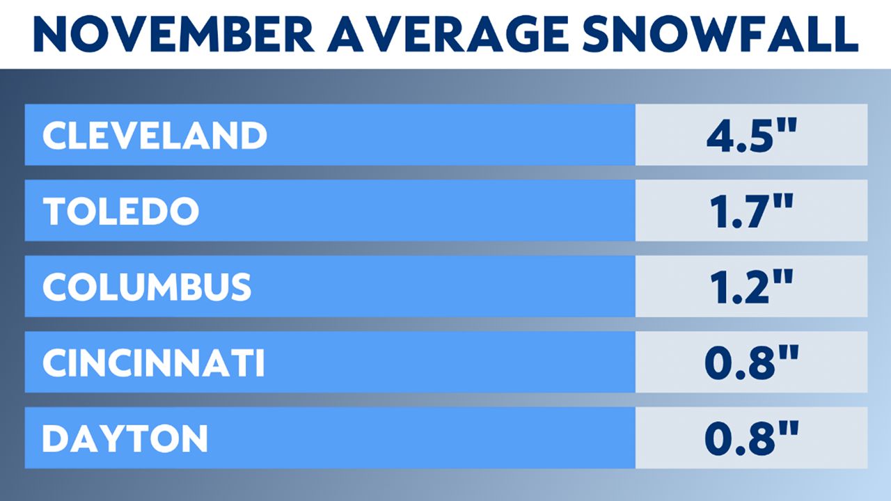
In lake-effect prone areas of Northeast Ohio, several inches of accumulation typically occur. Cleveland, Ashtabula and Youngstown are a few areas that average a few inches of snow during a normal November.
Believe it or not, even central and southern Ohio will witness significant November snowfall every so often. Back in 1950, the city of Columbus picked up just over 15 inches of snow during November, even though the normal is typically only around 1 inch.
While most of us think of late spring and early summer as prime severe weather season, a secondary spike in thunderstorms occurs during the Fall. Here in Ohio, the month of November is no stranger to severe storms. In Nov. 2002 and 2017, tornadoes and straight-line winds wreaked havoc on our state.

Flooding rainfall can also be a concern this time of year. Back in 1982, the city of Cincinnati recorded 15.05 inches of rain throughout the month.
This is certainly a month of change. With all the different kinds of weather and hazards possible in November, be sure to stay alert and follow along with Spectrum News 1 for the latest forecast information.
Our team of meteorologists dives deep into the science of weather and breaks down timely weather data and information. To view more weather and climate stories, check out our weather blogs section.