


Every time you tune in to your daily "Weather on the 1s" forecast, you’ll hear your average high or average precipitation.
These averages refer to our local normals that are come from the most recent 30-year climate period. Every decade, the National Oceanic and Atmospheric Administration updates the numbers.
NOAA's latest update to these climate averages represents the average temperatures, snowfall and precipitation from 1991 through 2020. Previously, our data was a snapshot from 1981 to 2010.
The difference between our previous climate data and our most recent thirty years’ worth may surprise you.
What we have found is mostly a rise in the average highs and lows along with an increase in annual average rainfall and snowfall.
Annual average temperatures warmed by 0.5 to 1.5 degrees statewide. That may not seem like a lot, but it's significant.
In Cleveland, the annual average temperature rose by one degree with seasonal warmups, as well. Each season showed a warmer average temperature, especially in the winter and summer.
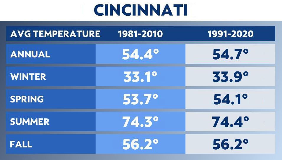
Cincinnati's average temperature warmed in 11 out of 12 months. The exception was November.
Here are the annual and seasonal changes in Columbus.
We've seen an increase in precipitation across the eastern half of the country. Across the Ohio Valley, rising temperatures affect our weather patterns.
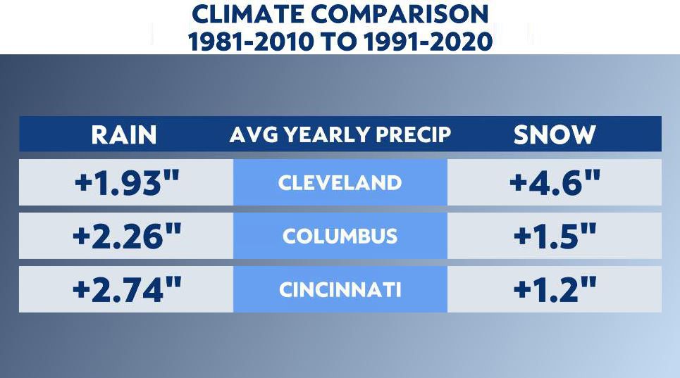
Locally, all three metros show this trend when comparing the two most recent 30-year normals. The biggest increase is in Cincinnati, whose normal yearly precipitation increased by almost three inches. Columbus data shows an annual rainfall increase of 2.26 inches and Cleveland went up by 1.93 inches.
The bigger picture supports warming months, so how does a warmer winter trend lead to more snow?
Let's start with Cleveland, which is located in the snowbelt region and is known for lake-effect snow systems.
If Lake Erie doesn't freeze over until much later in the winter season, then typically that will increase the lake-effect snow action for the snowbelt region. Or, if the lake thaws earlier in the spring, you can also have some spring lake snow, as well.
For the rest of the state, average yearly snowfall is up. The trend supports more frequent, small snowfalls driving that increase.
Cincinnati and Columbus have over an inch more yearly snowfall, on average.
You can get a full breakdown of the new climate numbers for cities throughout Ohio and the United States here.