


)
Meteorologists rely on accurate measurements when the flakes start to fly. Let's talk about measuring snowfall and how you can be a part of our coverage here in Ohio!
What You Need To Know
- A simple cardboard snowboard is all you need to get started
- Always choose a measuring point away from buildings and trees
- You can measure up to four times in 24 hours for accuracy
- Be mindful of drifting snow which can overinflate measurements
All In The Prep-Work

Accurate snowfall measurement starts with preparation. When the forecast calls for snow, the first thing to do is get a snowboard. A snowboard can be a piece of plywood or sturdy cardboard, at least 2 feet by 2 feet. It should be light in color, or painted light if you'd like.
Ideally, you will want to place this board outside somewhere away from buildings, trees, or any other disturbance that could potentially affect accumulation. You will also want to avoid any areas prone to drifting snow (more on that below). Mark the area with a stake or flag and you're done. Simple, right?
Ruler Time
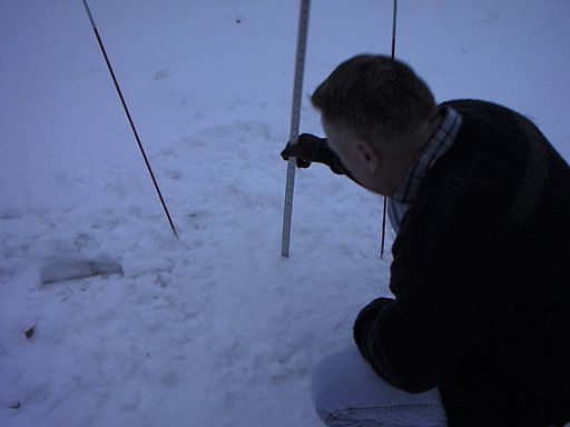
Once snow starts accumulating, you will want to think about measuring it. There are a few tips to gain accurate measurements.
First off, use a straight wooden ruler, not a tape measure which can bend. Next, use good judgement when choosing to measure. A general rule is no more than four times in 24 hours. If the snowfall is heavy, you'll want to get out there every few hours. Note the time and the amount, and use that to calculate how much additional snow has fallen since the last measurement. Snowfall is measured to the nearest tenth of an inch.
Really important – only clean off the snowboard after each measurement. Make sure to not only record your findings, but take a picture as well!
Although a foot-long ruler is usually fine, there are rare instances where you might need a yardstick. Snowfall rates in heavy, lake-effect snow have sometimes been recorded at 2-3 inches per hour! (Snowbelt areas, you know I'm talking about you.)
A Few Important Notes
Many times across Ohio, snow will mix with, and even change to sleet, freezing rain or even rain at times. This may seem complicated, but there are a few rules.
First, sleet accumulation does count toward snowfall amounts, but freezing rain does not. If snow melts continuously on contact, that can be recorded as a "trace" of snow for the period. While it's important to make sure your snowboard is placed in a good position to begin with, sometimes you can't help with strong wind drifts or uneven accumulations, even on that small surface. Drifts can be tricky.

Drifting Snow
As so many of you are aware, snow doesn't always just fall straight down. In fact, blowing and drifting snow is common, especially behind a front and in lake-effect cases. This can cause some areas to look like they've received many inches or even feet more than they have! So, what happens if your snowboard is caught in an inescapable deluge of snow drifts?
The answer is to take several measurements all across the area, even off the snowboard. You'll want to note where snow may have piled up excessively due to winds. Look for an increase in depth closer to trees, buildings, or any free standing objects. The trick is to find a few areas that seem to be a little less than average, and a few areas that seem a little more than average and note all measurements.
While not totally scientific, it's the best way to get as close to an accurate measurement as possible when the winds are really strong.
Send Us Your Measurements!
When you start taking your snowfall measurements, make sure to record them and send them our way. Not only is it a valuable tool for us, but your reports can help us track the heavy bands and more accurately adjust final snow amounts. We can be reached at OhioWeather@charter.com. Don't forget to include your city or town where you took your measurements. Snow selfies are welcome, too!