


It seems like in the blink of an eye we’ve gone from sunny summer days to fresh fall festivities. In fact, Ohio’s daytime highs have fallen 20 degrees from late September to early October!
Let’s break down the difference between frost and freeze first.
Frost is a layer of ice crystals that form when water vapor on plant matter condenses and freezes without first becoming dew.
The ideal overnight low for frost is between 33 to 39 degrees with fairly clear skies and little to no wind. The ground releases heat overnight and fewer clouds means more heat escapes back to space. This is called radiational cooling.
Little to no wind at night prevents the air from getting stirred up. The ground temperature can be up to 10 degrees cooler than where the temperature observation is takek, typically four to five feet above the surface.
Another major factor in the development of frost and freeze is location! Valleys are ideal for development of frost and freeze because as the cold air is heavier than warmer air and settles into valleys and low spots. This also creates a shelter from stronger winds and can enhance the potential for frost/freeze by morning.
Frosts tend to occur late at night or in the early hours of the morning. Tender plants probably suffer some damage while the hardier plants survive.
Toward the end of the growing season, freeze becomes inevitable as temperatures drop below freezing. A process called advection cooling can cause freezes to occur. Advection is when there is a transferring of heat or moisture by movement of an air mass.
Unlike frost events, freezes can be either short or long term.
A hard freeze is a period of at least four consecutive hours of air temperatures at our below 28 degrees. This usually will create widespread damage on plants.
Here are the definitions of the National Weather Service's frost and freeze alerts.
Frost Advisory: Issued when minimum temperatures are expected to be between 33 to 36 degrees. Skies are generally clear with calmer winds.
Freeze Watch: Issued when the minimum temperatures are expected to be 32 degrees or colder within the next 24 to 36 hours.
Freeze Warning: Issued when minimum temperatures are imminently expected to be 32 degrees or colder.
Hard Freeze Warning: Issued when minimum temperatures are expected to be 28 degrees or colder.
Keep in mind these are averages, and every year it varies.
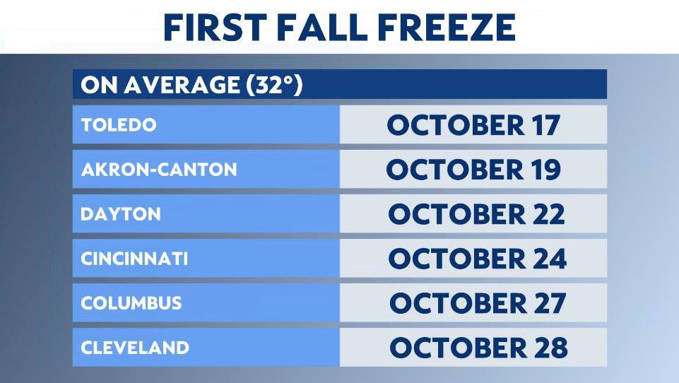
Below are the average first freeze dates for various cities in Ohio:
Akron-Canton: October 19
Bellefontaine: October 14
Chillicothe: October 17
Cincinnati: October 24
Circleville: October 19
Cleveland: October 28
Columbus: October 27
Dayton: October 22
Delaware: October 14
Greenville: October 12
Kenton: October 20
Mansfield: October 14
Marysville: October 22
Portsmouth: October 23
Springfield: October 13
Toledo: October 17
Wilmington: October 16
Xenia: October 20
Youngstown: October 14
Zanesville: October 14