


The peak of hurricane season 2020 isn't even here yet, and we've already had quite a few named storms. As August rolls into September, the heart of the busy season lies ahead, with the right conditions such as warm ocean waters ready to fuel tropical cyclones.
But while we usually associate hurricanes and tropical storms with the warm waters of the Caribbean, Mexico and the southern Atlantic (not to mention Hawaii), sometimes even unexpected regions can spawn storms that can be tropical in nature.
On that note, one of the most common questions I get asked all the time when talking about hurricanes is, "has a hurricane ever formed over one of the Great Lakes?"
While the short answer is "not really," the long answer is way more complicated and way more interesting!
What You Need To Know
- The Lake Huron Cyclone formed on Sept. 11, 1996
- While mostly subtropical in nature, some tropical characteristics were observed
- Over 4 inches of rain fell, and winds were up to 73 mph.
- The storm dissipated on Sept. 15, 1996
Back in September of 1996, a storm formed over the Great Lakes as a weak area of low pressure, specifically over Lake Superior. This area of low pressure had a northwest tilt and characteristics that indicated that rapid intensification would occur.
And wow... did it ever.
Before the end of that first day, winds had increased around the central low pressure at the surface from just over 10 mph to nearly 70 mph with some higher gusts.
)
By this time, the organization of the storm became even greater, due to the relatively warm waters of the lake.
Now, it's important to note that warm ocean waters over 80 degrees are favorable for tropical storm development.
Lake temperatures were clearly not as warm as say, the Caribbean, but for the time of year and the ripe upper level conditions, water temperatures in the 60s and 70s created a huge contrast between what it felt like at the surface versus right on the water.
This flux is oftentimes seen as a huge factor in strengthening storms in the wintertime that lead to significant snowstorms.
By the 13th to 14th of September, the storm's central area of circulation had moved over Lake Huron, partially due to a front coming in from the north that helped push the storm eastward. This movement helped to stack the storm's upper level in a more favorable condition for rapid intensification once again.
At it's peak, the lower-level area of circulation had dropped to nearly 993 millibars, which is comparable to a strong tropical storm. Surface winds increased to 73 mph, which is nearly the strength of a category 1 hurricane.
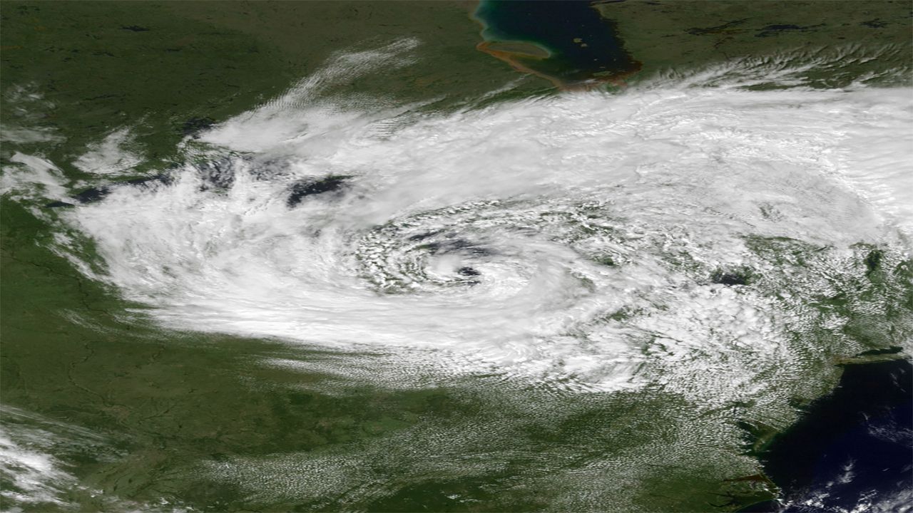
The imagery on satellite was nothing short of amazing; it truly looked like a hurricane had formed over the Great Lakes! The circulation was intense enough that even an "eye" about 20 miles in diameter formed.
In the end, by the 15th of September, the very thing that sometimes helps destroy hurricanes in the tropics, helped destroy this rare Great Lakes storm as well.
Strong upper-level wind shear helped rip apart the storm, causing it to become shallow and concentrate its energy on the surface. After squeezing out some more rain (nearly 4 inches fell in many spots along the lake) the system weakened, moved east, and eventually dissipated.
Later referred to as "Hurricane Huron", this extremely rare storm was an instance of how the right ingredients can come together and form something that was only speculated to be able to form previously. It's just another example of the awesome and extreme power of mother nature!