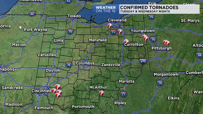
Survey teams from multiple National Weather Service officies have been busy the last few days investigating damage caused by the storms late Tuesday night in northern and eastern Ohio, and storm from Wednesday night in southern Ohio. As of publishing of this story, these teams have found at least 11 locations where tornadoes touched down in Ohio. Survey teams are still out investigating and additional confirmations are possible later today or tomorrow.
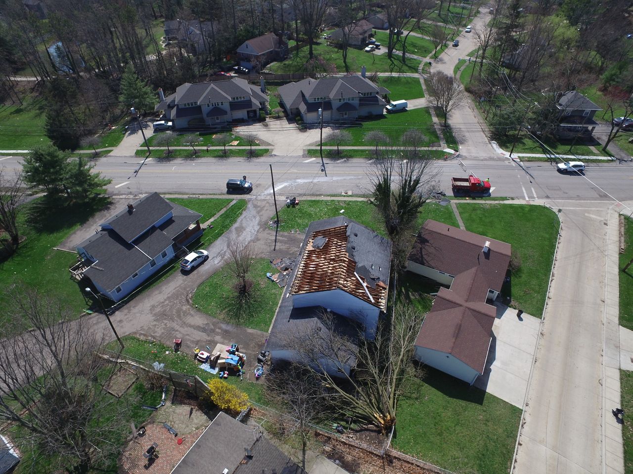
Medina/Lorain County: An EF-1 tornado with maximum winds of 100 mph, a maximum width of 100 yards, and path length of 11.48 miles touched down several miles southeast of Grafton in Lorain County at 11:30 PM EDT. A barn was destroyed at around 11:31 PM EDT in Grafton Township. The tornado path then became intermittent along the Lorain and Medina County line where damage consistent of an EF-0 was found. The tornado finally continued southeast into the city of Medina where both EF-0 and EF-1 damage was found. Extensive damage to trees and power lines was found in the city of Medina. The tornado lifted just south of the city of Medina at 11:40 PM EDT.
Summit County: An EF-1 tornado with estimated maximum winds of 90 mph, a maximum width of 100 yards, and a path length of 10.1 miles touched down in the town of Barberton in Summit County at 11:52 PM EDT. There was extensive damage to trees and power lines as well as numerous trees uprooted and blown down along the path. Some trees were snapped. Several trees fell on to homes, outbuildings, and cars. The tornado path then became intermittent between Barberton and Green as it tracked southeastward. The tornado finally lifted west of the Akron-Canton Regional Airport at 12:03 AM EDT on 04/08/2020.
Stark County: An EF0 tornado produced around 80 mph wind speeds. Intermittent Path starting 2 miles west of Massillon then to Sparta around 12:22 am, reaching the Stark/Tuscarawas County line near OH-800 at 12:30 am. Uprooted or damaged trees were observed along the intermittent path. Some of the trees did fall onto homes. A few homes had minor to moderate roof damage.
Tuscarawas County: This is a continuation of the tornado that impacted East Sparta in Stark County.The tornado resulted in damage to several modular homes and brought down numerous hardwood and softwood trees in the Sandy Valley Estates allotment along Route 800. It then moved across SR183 damaging two additional structures before moving toward Sandy Valley High School, where it toppled additional hardwood trees and damagedstructures near the ballfields.
This is the 16th tornado for Tuscarawas County since the 1880s for which we were notified of damage. The most recent tornado prior to this occurred on April 14th, 2019 when another EF0 tornado was observed.
Vinton County: Brief tornado touchdown occurred along Ohio 124 1.5 miles WNW of Wilkesville. A new double-wide mobile home was shifted off the block foundation and turned in a westerly direction. Nearby, a garage was destroyed. Another nearby mobile home was blown a few feet off it`s foundation in a southerly direction. Clear rotation was also evident in the direction several uprooted trees were laying and in debris scattered across the property.
Columbiana County 1: In East Fairfield, Damage Along This 5.6 Mile Path Was Relatively Continuous And Of Varying Intensity. Numerous Hardwood And Softwood Trees Suffered Damage, Either Being Uprooted Or Snapped At The Trunk Completely. Some Outbuildings Lost Metal Roof Panels, And One Less-Sturdy Building Lost Walls, Causing It To Collapse Completely. This Ef1 Tornado Track Ended Along Carmel Achor Road Just West Of State Route 170.
Columbiana County 2: In Union Ridge, A Second, Discrete But Compact Track Of Damage Was Noted Beginning To The West Of The Prior Tornado Track Along Carmel Achor Road And Coincident With A Separate Radar-Indicated Circulation. This 4.1 Mile Track Appears To Be Limited To Tree Damage. The Track Crossed Route 170 And Curved Along Pancake Clarkson Road, Crossing At The State Line With Pennsylvania. The Ef0 Tornado Path Continued Into Beaver County Pa And Rapidly Weakened.
Brown County 1:
Start Location...2 miles southwest of Fayetteville in Brown County Ohio
End Location...1 mile south-southwest of Fayetteville in Brown County Ohio
Date...Apr 8 2020
Estimated Starting Time...10:57 pm EDT
Estimated Ending Time...10:59 pm EDT
Maximum EF-Scale Rating...EF-0
Estimated Maximum Wind Speed...75 mph
Brown County 2:
.Lake Lorelei Tornado...
Start Location...3 miles west of Fayetteville in Brown County Ohio
End Location...1 mile northwest of Fayetteville in Brown County Ohio
Date...Apr 08 2020
Estimated Start Time...10:57 PM EDT
Estimated End Time...11:00 PM EDT
Maximum EF-Scale Rating...EF-0
Estimated Maximum Wind Speed...80 mph
Maximum Path Width...200 yards
Path Length...2.5 miles
Clinton Into Brown County: This EF0 tornado touched down in far southwestern Clinton County just west of SR-123. It moved east southeast across SR-123, lifting just across the Brown County border.
Clermont County: EF0 tornado near Edenton. This tornado caused tree damage on Garrison Spurling Road, and roof damage to homes on Edenton Pleasant Plain Road.