


A strong winter storm has arrived in Ohio and is bringing a mix of snow, freezing rain, sleet and just rain across Ohio. Temperatures are now falling rapidly across the state and any rain or sleet will quickly change to all snow through the night. The snow will become heavy at times, especially along the I-71 corridor overnight into very early Sunday. Strong wind gusts up to or over 40mph will create near white-out or blizzard-like conditions at times. Here is the specific forecast across Ohio.
TOLEDO and NORTHWEST OHIO
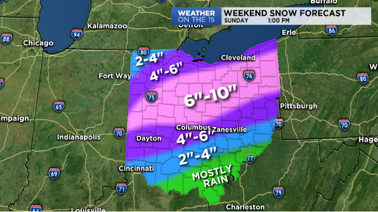
A WINTER STORM WARNING remains in effect until 4:00 am Sunday. Snow will be heavy at times this through tonight. Snow accumulation of 4 to 7 inches is expected through tonight. In addition to the heavy snow, northeast winds will gust to between 30 and 40 mph with the strongest winds across Northwest Ohio and near Lake Erie. Blowing and drifting of snow is expected and will contribute to reduced visibilities. Much colder air will arrive behind this system on Sunday with wet surfaces freezing and becoming slick. Wind chill values will fall to between zero and 20 below on Sunday night.. A Winter Storm Warning for snow means severe winter weather conditions will make travel very hazardous or impossible.
CLEVELAND and NORTHEAST OHIO
A WINTER STORM WARNING is in effect until 4:00 am Monday. A winter storm will bring heavy snow and strong winds to the area today and tonight followed lake effect snow on Sunday... Snow will be heavy at times tonight. Snow accumulations of 6 to 10 inches with isolated higher amounts will be possible. This system will quickly depart to the East Coast by Sunday and will be followed by lake effect snow later Sunday and Sunday night across the snow belt. In addition to the heavy snow, northeast winds will gust to between 30 and 40 mph with the strongest winds across Northwest Ohio and near Lake Erie. Blowing and drifting of snow is expected and will contribute to reduced visibilities. Much colder air will arrive behind this system on Sunday with wet surfaces freezing and becoming slick. Wind chill values will fall to between zero and 20 below on Sunday night.
COLUMBUS and CENTRAL OHIO
A WINTER STORM WARNING is in effect until 4:00 am Sunday. Rain sleet and snow will change to all snow tonight. Expect winds of 20 to 30 mph tonight with wind gusts up to 45 mph to overspread the entire area. Snow is expected to increase in intensity with some locations observing near blizzard conditions late tonight and into the early overnight period. Snow accumulations of between 4 to 8 inches are possible with higher amounts north of I-70. Travel conditions, especially near and north of the I-71 corridor, will quickly deteriorate late this evening, becoming hazardous and potentially dangerous. Flash freeze will be possible on some roads, with blowing and drifting snow causing brief whiteout conditions late this evening through the early overnight period. Snow is expected to diminish in coverage and intensity towards daybreak Sunday. Wind chills will fall to the single digits below zero and above zero by Sunday morning. Try to avoid going outdoors late this evening through early Sunday morning due to bitterly cold temperatures and hazardous road conditions.
CINCINNATI and SOUTHWEST OHIO
A WINTER STORM WARNING is in effect until 8:00 am Sunday. Heavy mixed will change to all snow tonight. Total snow accumulations of 2 to 5 inches and ice accumulations of around one tenth of an inch will possible. Winds will also be gusting as high as 45 mph. Travel could become very difficult overnight. Widespread blowing snow could significantly reduce visibility by late evening into tonight. A Winter Storm Warning means significant amounts of snow, sleet and ice will make travel very hazardous or impossible.
DAYTON METRO and WEST CENTRAL OHIO
A Winter Storm Warning is in effect until 4:00 am Sunday. Snow, heavy at times is expected through the night. Expect winds of 20 to 30 mph tonight with wind gusts up to 45 mph to overspread the entire area. Snow is expected to increase in intensity with some locations observing near blizzard conditions late this overnight. Snow accumulations of between 4 to 8 inches are possible with higher amounts north of I-70. Travel conditions will quickly deteriorate, becoming hazardous and potentially dangerous. Flash freeze will be possible on some roads, with blowing and drifting snow causing brief whiteout conditions late this evening through the early overnight period. Snow is expected to diminish in coverage and intensity towards daybreak Sunday. Wind chills will fall to the single digits below zero and above zero by Sunday morning. Try to avoid going outdoors late this evening through early Sunday morning due to bitterly cold temperatures and hazardous road conditions.
SOUTHEAST OHIO
A FLOOD WATCH and WINTER WEATHER ADVISORY are in effect through Sunday morning. Mostly rain will fall through the afternoon but will begin to mix with sleet and potentially freezing rain as colder air pushes into the area overnight. A quick transition to snow is expected after midnight with snow accumulations of up to 1 to 2 inches. A flash-freeze is also likely with wet conditions quickly becoming icy as temperatures fall rapidly tonight. This will lead to slick conditions on any untreated surfaces. Heavy rain is also likely before the transition to snow and may lead to flooding. A Winter Weather Advisory for snow means periods of snow will cause primarily travel difficulties. Expect snow covered roads and limited visibilities, and use caution while driving.