


The chances are you’ve likely heard of the potential major winter storm forecast to impact the Ohio Valley this weekend. There has been a lot of information, some of it good, and some of it not so good, circulating on the internet and in other places. The truth is, any future projections of the storm thus far are really just educated guesses based on some of the modeling data. But the models have been going back and forth on where the heaviest snow could fall. They have also been dramatically going back and forth on precipitation amounts, which will vastly determine the impact on travel and other events for the upcoming weekend. The National Weather Service in Cleveland tweeted Wednesday morning that the forecast model’s projects on the potential winter storm are like “throwing darts at a board”.
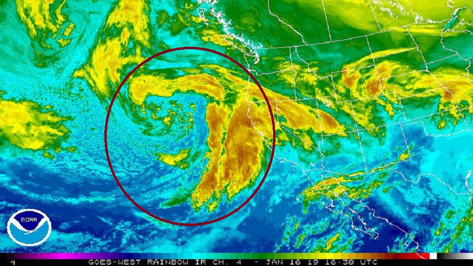
That all being said, the modeling is about to get a lot better over the next 24 to 48 hours (Thursday into Friday) as the system draws closer. But why are we waiting so late to get a good forecast on this winter storm? The reason is that up until tomorrow some time, the storm has been… and is still over the Pacific Ocean. The National Weather Service launches weather balloons from multiple land-based locations at least twice per day. While we can get a good sampling of the coming storm from satellites, ocean weather buoys and some ships, we will get a lot better data once the storm gets onshore of the west coast.
Once on shore, NWS weather balloons will be able to be launched into the storm system. These balloons will provide valuable data such as air pressure, temperature at different levels in the atmosphere, moisture amounts and winds. All of this data gets fed into the weather computer models which generate forecasts 2 to 4 times per day. Once this data can get fed into the computer models, it may take a few runs of the models to stabilize on the strength and track of the upcoming storm system. Another test for the upcoming storm will be the impact of the Rocky Mountains on the system. Because the mountains are vast and tall, they can have subtle impacts on the strength and track of the storm as it emerges into the Plains.
The bottom line is that meteorologists will soon be getting a lot more valuable weather information once this massive storm system makes it onshore early Thursday. It may take another 18 to 24 hours once the storm is on shore for the weather balloons, and thus forecast models to get the best sampling of the storm. By late Thursday into early Friday, meteorologists will have a much better, more detailed projection of where this winter storm is headed and who will get the heavy snow… and who will get the potential for ice.
But don’t wait to get prepared for the potential storm. Now is the time to be sure you have your emergency survival kit ready – just in case. It is always a good idea to make sure you have a supply of non-perishable food, warm blankets, extra clothes and batteries, along with bottled water. It will also be a good idea to make sure you have your mobile phones charged and ready, just in case power goes out. Remember to make sure your smoke detectors and CO2 detectors are in working order. Finally, be sure you keep up-to-date on the latest forecasts and the Spectrum News App.