

FLOODING
Kentucky historian recounts recent flood’s historical context
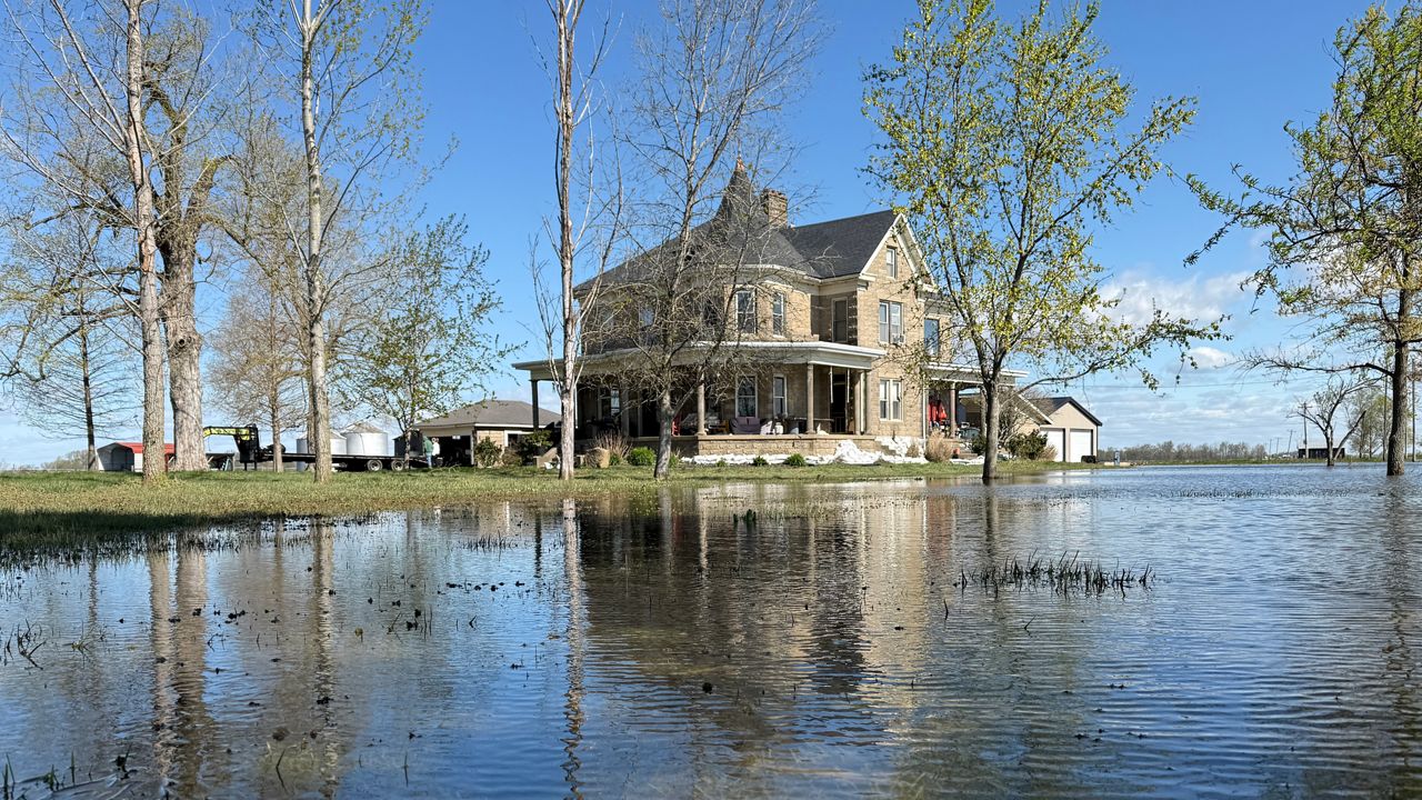
Grady Ebelhar said the latest flood didn’t reach the heights of 1937.
2:17
Active Weather Alerts for Green Bay, WI
| Location | Alert Type |
|---|---|
| Pulaski 04/17/2025 9:00 AM | Frost Advisory Details |
| ...FROST ADVISORY IN EFFECT FROM MIDNIGHT TONIGHT TO 9 AM EDT THURSDAY... * WHAT...Temperatures falling into the mid 30s in valleys will result in areas of frost formation. Temperatures could approach freezing in the coldest hollows. For ridgetops and locations adjacent to Lake Cumberland, temperatures are expected to remain milder, dipping mainly into the upper 30s, limiting or preventing frost formation there. * WHERE...McCreary, Pulaski, and Wayne Counties. * WHEN...From midnight tonight to 9 AM EDT Thursday. * IMPACTS...Frost could harm sensitive outdoor vegetation. Sensitive outdoor plants may be killed if left uncovered. PRECAUTIONARY/PREPAREDNESS ACTIONS... Take steps now to protect tender plants from the cold. | |
| Fleming 04/17/2025 9:00 AM | Frost Advisory Details |
| ...FROST ADVISORY REMAINS IN EFFECT FROM MIDNIGHT TONIGHT TO 9 AM EDT THURSDAY... * WHAT...Temperatures falling into the low and mid 30s are expected in valleys, resulting in frost formation. A light freeze with temperatures dipping to near 30 is possible in the coldest hollows. For ridgetops, temperatures are expected to remain milder, dipping mainly into the upper 30s to lower 40s, limiting or preventing formation there. * WHERE...Portions of east central, northeast, south central, and southeast Kentucky. * WHEN...From midnight tonight to 9 AM EDT Thursday. * IMPACTS...Frost could harm sensitive outdoor vegetation. Sensitive outdoor plants may be killed if left uncovered. PRECAUTIONARY/PREPAREDNESS ACTIONS... Take steps now to protect tender plants from the cold. | |
| Montgomery 04/17/2025 9:00 AM | Frost Advisory Details |
| ...FROST ADVISORY REMAINS IN EFFECT FROM MIDNIGHT TONIGHT TO 9 AM EDT THURSDAY... * WHAT...Temperatures falling into the low and mid 30s are expected in valleys, resulting in frost formation. A light freeze with temperatures dipping to near 30 is possible in the coldest hollows. For ridgetops, temperatures are expected to remain milder, dipping mainly into the upper 30s to lower 40s, limiting or preventing formation there. * WHERE...Portions of east central, northeast, south central, and southeast Kentucky. * WHEN...From midnight tonight to 9 AM EDT Thursday. * IMPACTS...Frost could harm sensitive outdoor vegetation. Sensitive outdoor plants may be killed if left uncovered. PRECAUTIONARY/PREPAREDNESS ACTIONS... Take steps now to protect tender plants from the cold. | |
| Bath 04/17/2025 9:00 AM | Frost Advisory Details |
| ...FROST ADVISORY REMAINS IN EFFECT FROM MIDNIGHT TONIGHT TO 9 AM EDT THURSDAY... * WHAT...Temperatures falling into the low and mid 30s are expected in valleys, resulting in frost formation. A light freeze with temperatures dipping to near 30 is possible in the coldest hollows. For ridgetops, temperatures are expected to remain milder, dipping mainly into the upper 30s to lower 40s, limiting or preventing formation there. * WHERE...Portions of east central, northeast, south central, and southeast Kentucky. * WHEN...From midnight tonight to 9 AM EDT Thursday. * IMPACTS...Frost could harm sensitive outdoor vegetation. Sensitive outdoor plants may be killed if left uncovered. PRECAUTIONARY/PREPAREDNESS ACTIONS... Take steps now to protect tender plants from the cold. | |
| Rowan 04/17/2025 9:00 AM | Frost Advisory Details |
| ...FROST ADVISORY REMAINS IN EFFECT FROM MIDNIGHT TONIGHT TO 9 AM EDT THURSDAY... * WHAT...Temperatures falling into the low and mid 30s are expected in valleys, resulting in frost formation. A light freeze with temperatures dipping to near 30 is possible in the coldest hollows. For ridgetops, temperatures are expected to remain milder, dipping mainly into the upper 30s to lower 40s, limiting or preventing formation there. * WHERE...Portions of east central, northeast, south central, and southeast Kentucky. * WHEN...From midnight tonight to 9 AM EDT Thursday. * IMPACTS...Frost could harm sensitive outdoor vegetation. Sensitive outdoor plants may be killed if left uncovered. PRECAUTIONARY/PREPAREDNESS ACTIONS... Take steps now to protect tender plants from the cold. | |
| Powell 04/17/2025 9:00 AM | Frost Advisory Details |
| ...FROST ADVISORY REMAINS IN EFFECT FROM MIDNIGHT TONIGHT TO 9 AM EDT THURSDAY... * WHAT...Temperatures falling into the low and mid 30s are expected in valleys, resulting in frost formation. A light freeze with temperatures dipping to near 30 is possible in the coldest hollows. For ridgetops, temperatures are expected to remain milder, dipping mainly into the upper 30s to lower 40s, limiting or preventing formation there. * WHERE...Portions of east central, northeast, south central, and southeast Kentucky. * WHEN...From midnight tonight to 9 AM EDT Thursday. * IMPACTS...Frost could harm sensitive outdoor vegetation. Sensitive outdoor plants may be killed if left uncovered. PRECAUTIONARY/PREPAREDNESS ACTIONS... Take steps now to protect tender plants from the cold. | |
| Laurel 04/17/2025 9:00 AM | Frost Advisory Details |
| ...FROST ADVISORY REMAINS IN EFFECT FROM MIDNIGHT TONIGHT TO 9 AM EDT THURSDAY... * WHAT...Temperatures falling into the low and mid 30s are expected in valleys, resulting in frost formation. A light freeze with temperatures dipping to near 30 is possible in the coldest hollows. For ridgetops, temperatures are expected to remain milder, dipping mainly into the upper 30s to lower 40s, limiting or preventing formation there. * WHERE...Portions of east central, northeast, south central, and southeast Kentucky. * WHEN...From midnight tonight to 9 AM EDT Thursday. * IMPACTS...Frost could harm sensitive outdoor vegetation. Sensitive outdoor plants may be killed if left uncovered. PRECAUTIONARY/PREPAREDNESS ACTIONS... Take steps now to protect tender plants from the cold. | |
| Whitley 04/17/2025 9:00 AM | Frost Advisory Details |
| ...FROST ADVISORY REMAINS IN EFFECT FROM MIDNIGHT TONIGHT TO 9 AM EDT THURSDAY... * WHAT...Temperatures falling into the low and mid 30s are expected in valleys, resulting in frost formation. A light freeze with temperatures dipping to near 30 is possible in the coldest hollows. For ridgetops, temperatures are expected to remain milder, dipping mainly into the upper 30s to lower 40s, limiting or preventing formation there. * WHERE...Portions of east central, northeast, south central, and southeast Kentucky. * WHEN...From midnight tonight to 9 AM EDT Thursday. * IMPACTS...Frost could harm sensitive outdoor vegetation. Sensitive outdoor plants may be killed if left uncovered. PRECAUTIONARY/PREPAREDNESS ACTIONS... Take steps now to protect tender plants from the cold. | |
| Bell 04/17/2025 9:00 AM | Frost Advisory Details |
| ...FROST ADVISORY REMAINS IN EFFECT FROM MIDNIGHT TONIGHT TO 9 AM EDT THURSDAY... * WHAT...Temperatures falling into the low and mid 30s are expected in valleys, resulting in frost formation. A light freeze with temperatures dipping to near 30 is possible in the coldest hollows. For ridgetops, temperatures are expected to remain milder, dipping mainly into the upper 30s to lower 40s, limiting or preventing formation there. * WHERE...Portions of east central, northeast, south central, and southeast Kentucky. * WHEN...From midnight tonight to 9 AM EDT Thursday. * IMPACTS...Frost could harm sensitive outdoor vegetation. Sensitive outdoor plants may be killed if left uncovered. PRECAUTIONARY/PREPAREDNESS ACTIONS... Take steps now to protect tender plants from the cold. | |
| Clay 04/17/2025 9:00 AM | Frost Advisory Details |
| ...FROST ADVISORY REMAINS IN EFFECT FROM MIDNIGHT TONIGHT TO 9 AM EDT THURSDAY... * WHAT...Temperatures falling into the low and mid 30s are expected in valleys, resulting in frost formation. A light freeze with temperatures dipping to near 30 is possible in the coldest hollows. For ridgetops, temperatures are expected to remain milder, dipping mainly into the upper 30s to lower 40s, limiting or preventing formation there. * WHERE...Portions of east central, northeast, south central, and southeast Kentucky. * WHEN...From midnight tonight to 9 AM EDT Thursday. * IMPACTS...Frost could harm sensitive outdoor vegetation. Sensitive outdoor plants may be killed if left uncovered. PRECAUTIONARY/PREPAREDNESS ACTIONS... Take steps now to protect tender plants from the cold. | |
| Carter 04/17/2025 9:00 AM | Frost Advisory Details |
| ...FROST ADVISORY REMAINS IN EFFECT UNTIL 9 AM EDT THURSDAY... * WHAT...Temperatures as low as 32 will result in frost formation. * WHERE...Portions of northeast Kentucky, southeast Ohio, and central, northern, southern, and western West Virginia. * WHEN...Until 9 AM EDT Thursday. * IMPACTS...Frost could harm sensitive outdoor vegetation. Sensitive outdoor plants may be killed if left uncovered. PRECAUTIONARY/PREPAREDNESS ACTIONS... Additional INFO can be found at https://www.weather.gov/rlx as well as on our Facebook and Twitter pages. | |
Grady Ebelhar said the latest flood didn’t reach the heights of 1937.
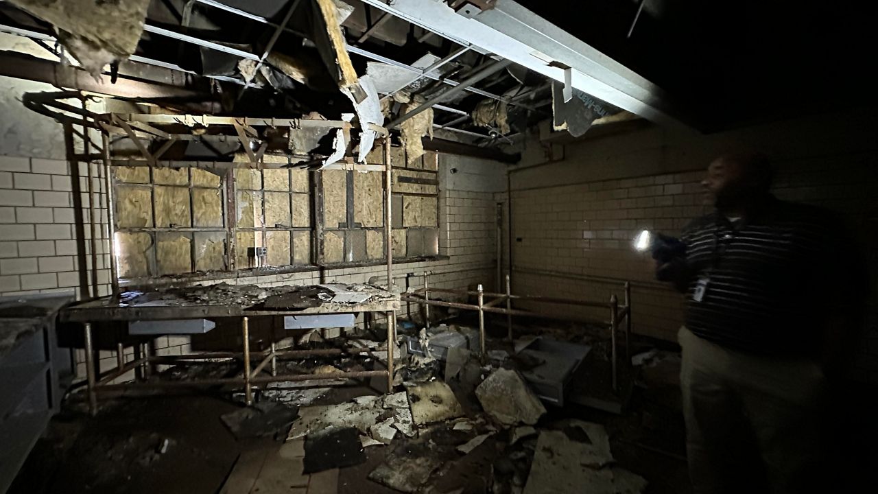
For Phase 1, Men 2 Be is hoping to use the building as a tornado shelter, a recreation center and office spaces for their mission.
Louisville Metro Police Chief Paul Humphrey shared positive data related to homicides, shootings and robberies.
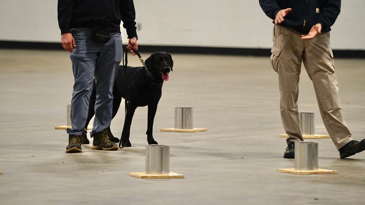
Over 30 local, state and federal teams are participating in the three-day training and evaluation session.

BourbonVille is a bourbon tasting that not only features the state's signature spirit, but will also highlight a Kentucky Proud memu.

The long annual journey northward continues for the Ruby-Throated Hummingbirds.