Even though forecasting snowfall is often tricky, the National Weather Service (NWS) expects an update to Winter Storm Warnings will make them clearer.
In the past, the NWS issued Winter Storm Warnings based on how much snow was expected either within a 12-hour or 24-hour period. While there was some consistency among neighboring NWS offices, there were still issues that could make warnings confusing.
The NWS approached the problem from a national view and collaborate with local NWS offices and their partners, such as media and emergency management, to work through having a consistent message.
“The new criteria uses improved science (that is, an improved snowfall climatology) that better represents the amounts of snow an area typically receives and the impacts that would likely result,” says Eric Guillot, Winter Program Coordinator for the NWS.
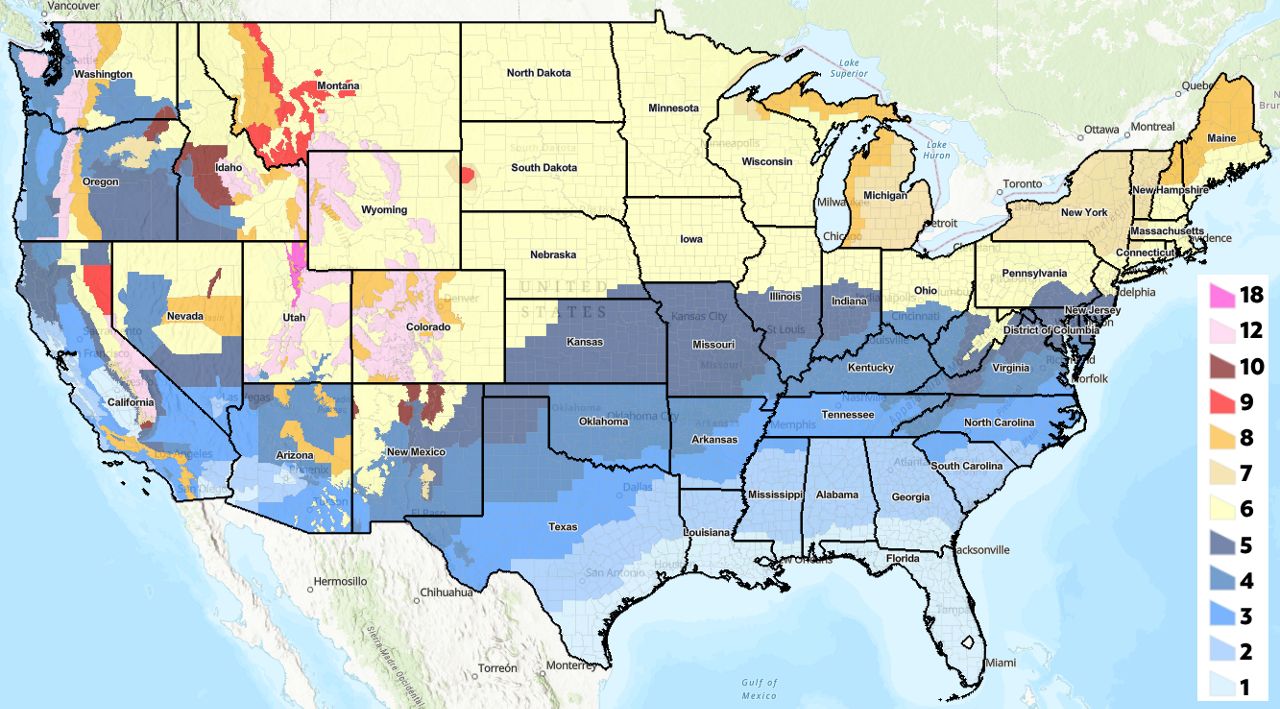
Those snowfall amounts are now based on an entire snowfall event capped at 48 hours, rather than 12-hour or 24-hour limits. “Generally, most areas only changed their criteria by 1 or 2 inches. Some areas did not change their criteria at all,” adds Guillot.

See an interactive version of this map here.
Like before, there’s still some leeway on those thresholds. For example, if the local Winter Storm Warning criteria is 6 inches and only 5 inches is expected, but it’ll come with 25 mph winds or become really heavy during a rush hour, then a warning can still get issued because of those outsized effects. On the flip side, if it’s a borderline 6-inch snow falling through the entire 48-hour span, making impacts small, then the NWS may opt to not go with a warning.
Guillot also says the national approach helped remove non-weather-related inconsistencies between NWS offices. Those would sometimes make maps of winter weather alerts a confusing patchwork that impeded sending out a clear message of what to expect.
The NWS also produces a Winter Storm Severity Index (WSSI), which predicts impacts of anything from snowfall amounts to fast-freezing roadways. The WSSI’s snowfall climatology is the same one that the new Winter Storm Warnings use, which will help make the WSSI impact forecasts clearer.
Our team of meteorologists dives deep into the science of weather and breaks down timely weather data and information. To view more weather and climate stories, check out our weather blogs section.
Justin Gehrts - Senior Weather Producer
Justin Gehrts is a senior weather producer for Spectrum News. He has well over a decade of experience forecasting and communicating weather information. Gehrts began his career in 2008 and has been recognized as a Certified Broadcast Meteorologist by the American Meteorological Society since 2010.


