


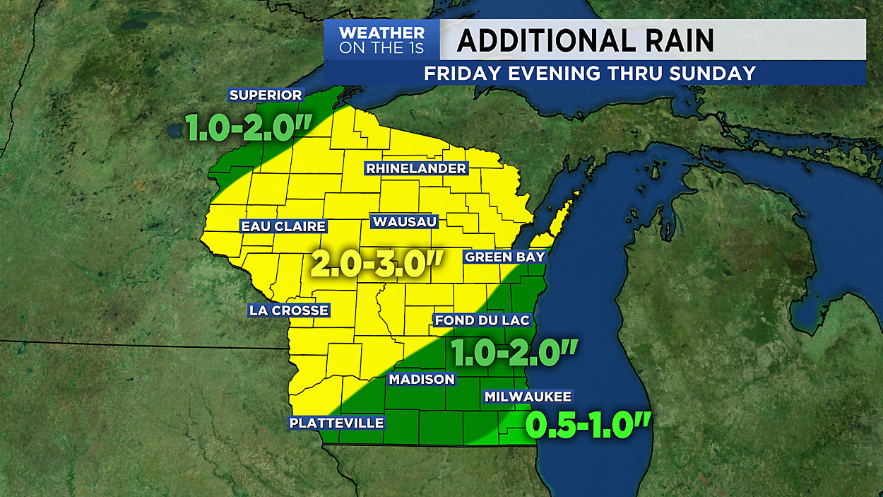
It looks to be mainly an "inside weekend" for those in the Milwaukee area - and for those all across Wisconsin for that matter. There will be rain and thunderstorms at times, with the highest rain totals found in central and northern Wisconsin. The Milwaukee area will pick up between 0.5" and 1.5" from Friday evening through Sunday, but that's getting off easy considering much of the rest of the state will pick up 2.0" to 3.0" before the rain shuts down.
GREATER MILWAUKEE AREA FORECAST:
Friday night: Cloudy with scattered showers, possible a T-storm. | Low: 44 | Wind: NE 5-10mph
Saturday: Cloudy with occasional showers and T-storms, especially in the afternoon. | High: 60 Lakefront, 74 Inland | Wind: E becoming S 5-10mph
Saturday night: Cloudy with occasional showers and T-storms. | Low: 53 | Wind: S becoming SE 5-10mph
Sunday: Cloudy with occasional showers and T-storms. | High: 70 | Wind: S becoming SW 10-20mph
Monday: Mostly sunny and cooler. | Low: 44 | High: 57
Tuesday: Mostly cloudy and cool with a good chance of scattered showers and T-storms. | Low: 42 | High: 50 Lakefront, 57 Inland
Wednesday: Mostly sunny and much warmer. | Low: 48 | High: 75
Thursday: Mostly sunny. | Low: 54 | High: 72
Friday: Partly sunny. | Low: 50 | High: 73
Follow the "Weather On the 1s" Team on social media for the latest weather updates:
Chief Meteorologist JD Rudd: Facebook | Twitter
Meteorologist Kristin Ketchell: Facebook | Twitter | Instagram
Meteorologist Brooke Brighton: Facebook | Twitter | Instagram