


MADISON, Wis. (SPECTRUM NEWS) - Scientists have created a database using cell phone data to track people’s movements by county, which could help experts fight the spread of coronavirus.
UW-Madison’s Geospatial Data Science Lab had already been researching people’s connections to the places around them. Their system uses anonymized cell phone data to measure how far people are moving from their homes every day. Because it’s anonymized to protect privacy, the scientists can’t single out any one cell phone user, and they don't have information about any individual person.
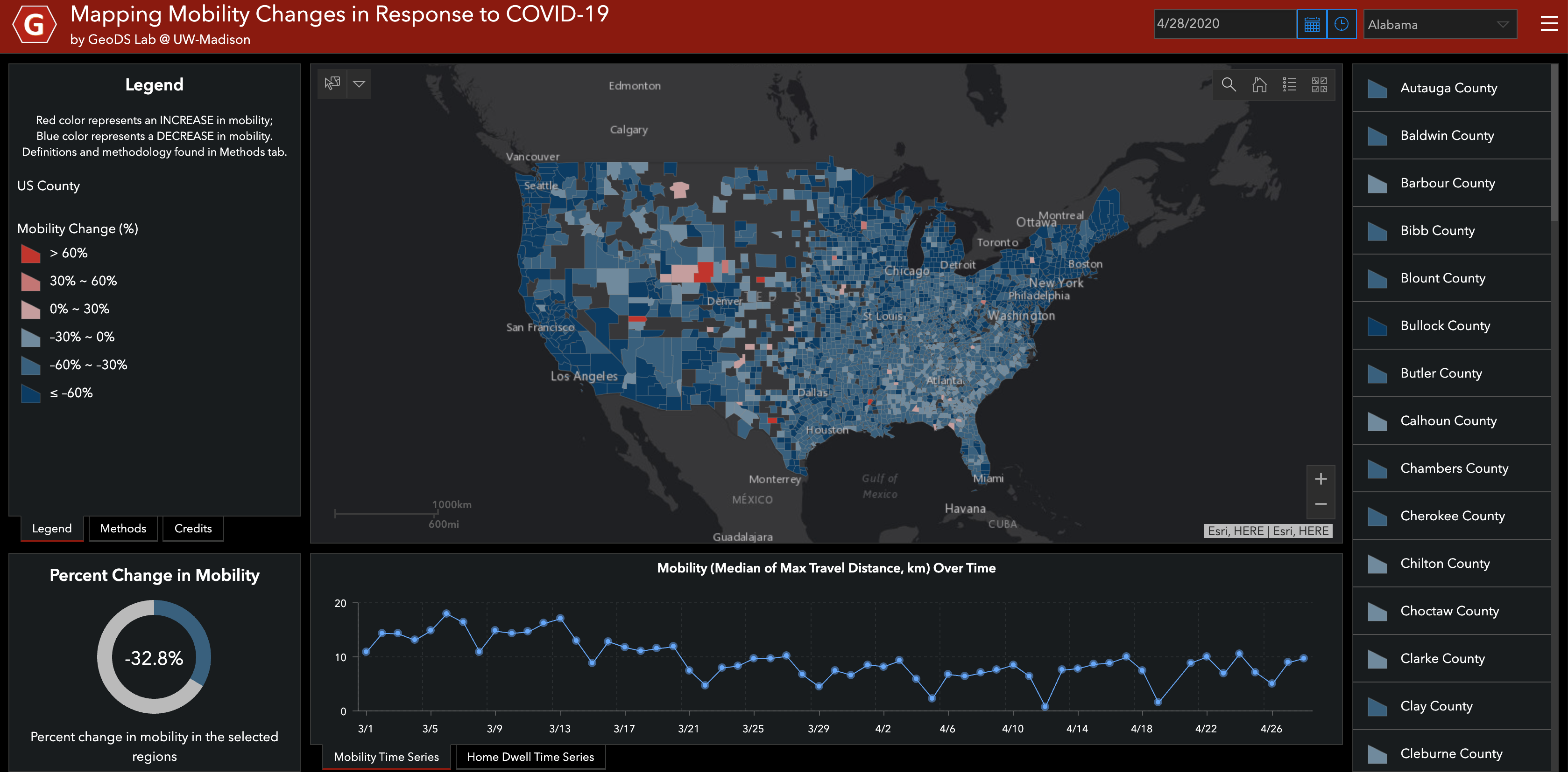
Their database takes data about how far people traveled from their homes, takes the median number, and organizes it by day. You end up seeing a line per county that shows the rate of people’s movement.
“What we’ve been doing might be actually good for tracking the human activities and movements during this pandemic,” said Song Gao, an assistant professor of geography on the Geospatial Data Science Lab team. “As well as understanding how people react to the social distancing guidelines at different scales.”
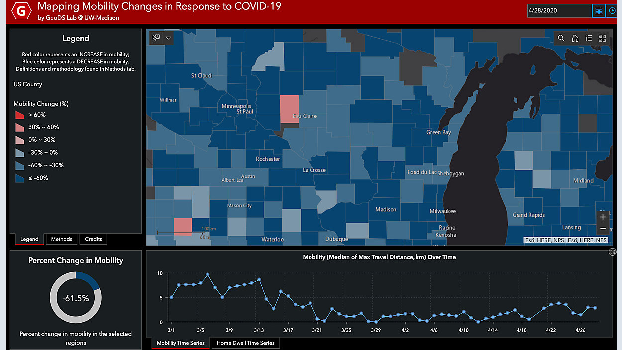
[[STATEWIDE MAP]]
This technology can give us valuable information, like which communities are doing a good job at social distancing, and which ones aren’t. That can change day to day. Overall, Wisconsinites are moving 61 percent less than they were before the pandemic hit.
April 7, election day in Wisconsin, is one example of seeing changes in movement. There were spikes in counties across the state, some big, some small. Since March 28, on average, Waukesha County residents had been going .78 kilometers from their homes per day. On election day, the data shows people went almost 2 kilometers from their homes. There was one polling place in the city of Waukesha.
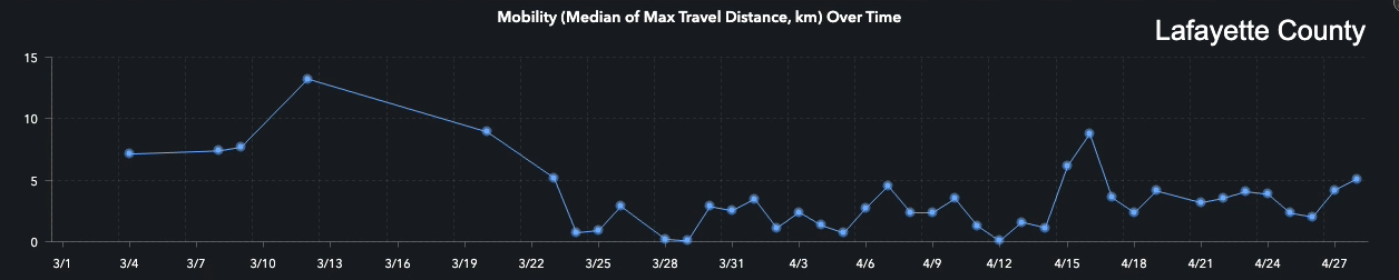
Other counties had jumps in movement on election day too. In Lafayette County, the data shows that since March 28, people were moving 1.27 kilometers from their homes per day. On April 7, the data shows people went 4.5 kilometers from home on average. It was the first time since the Safer At Home order went into effect that the mobility of residents was over 4 kilometers. “Based on our mapping tool, we did see the increase on that day for sure,” said Gao.
Right now, the data shows evidence of what social media has dubbed “the seven-week itch”. Many counties across Wisconsin have had increased movement in the last week to ten days.
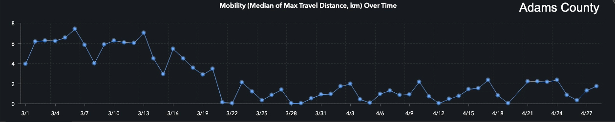
For example, three weeks ago in Adams County, people were staying home big time: on average, they went less than a kilometer away from their homes most days. Over the last week, that number jumped to more than 2 kilometers on one day, and up to almost 5 kilometers on Sunday, April 26.
.jpg)
That’s a trend we’re seeing statewide: people are moving more now than they were in the previous weeks of the pandemic. Movement levels spiked to their highest level since the Safer At Home order was issued April 22-24.
.jpg)
Two of the state’s more populated areas have been doing among the best at staying home. In Milwaukee County, there’s not a single day where on average, people went one kilometer from their homes. Overall, the rate of movement in Milwaukee County has dropped 94 percent since the weeks before the COVID-19 crisis.
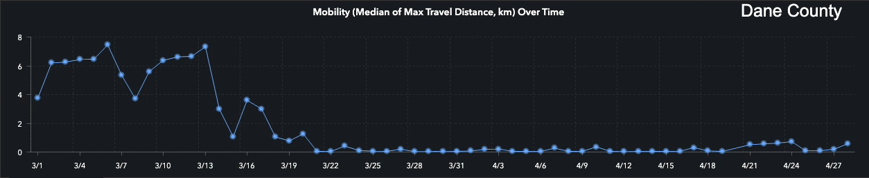
The same can be said for Dane County. Residents there are moving 92 percent less than they were in late February and early March. On average, residents haven’t traveled more than a kilometer from their homes since the Safer At Home order was issued. The data shows most people aren’t going more than half a mile from their home most days.
This may seem like just a lot of numbers and statistics, but this data could be invaluable right now. “Our tool output could be potentially using those epidemiology modeling, and public health policy modelings,” said Gao.
Public health communications experts can see whether people are listening to their advice, and tailor their message to the results. Infectious disease doctors and researchers can see where there may be more cases in the future. Each one of us can see whether our neighbors are staying safe by staying home.
To access the data yourself, click here.
This project by the Geospatial Data Science lab is funded by the National Science Foundation.