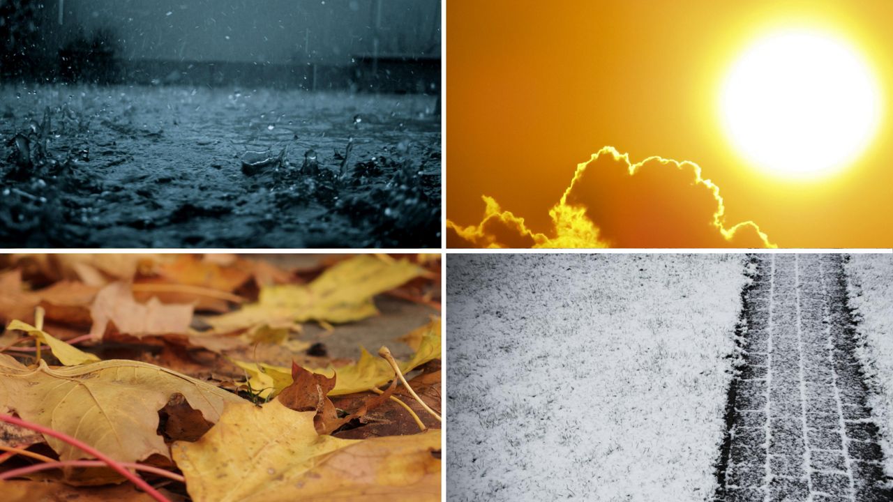
As we say goodbye to 2022, we take a moment to reflect on how our weather played out this year. From tornadoes to rare heat, bitter cold and meaningful snow… we had it all this year.
JANUARY
We start with a look at Jan. 2022, where cold air paid us a visit to start the new year. Lows fell below zero for several nights across much of the state. At the end of the month, many spots saw overnight lows tumble to nearly 20 degrees below zero. Even for Wisconsin, that’s cold!
It was also a bit of a snowy beginning to 2022. Southern Wisconsin picked up nearly four inches of snow on New Year’s Day. By the end of the month, many other locales also saw a few more inches of snowfall. On average, January is the snowiest month of the year.
FEBRUARY
What has been a frigid month in recent years was not so this time around. By the third week, highs spiked into the 50s across much of the state. An early sign of spring? Not quite.
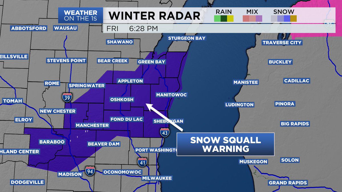
Just because it was warm doesn’t mean we escaped the snow. Nearly half of the month featured days with snowfall. And back on Jan. 18, the National Weather Service issued the first Snow Squall Warning in our state. That was because of heavy bands of snow and wind gusts around 70 mph.
MARCH
The third month of the year was a seasonal tug-o-war. Temperatures were all over the place throughout the month, including a rare 70-degree day in the middle of March.
Most of the month was snowflake free until the very end, when many spots picked up a few inches of snow. However, there was plenty of rain throughout the month.
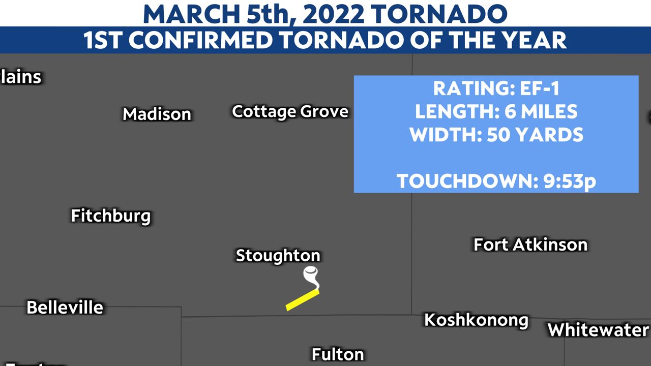
Severe weather season also got an early start as our first warnings of the year came on March 5. The same day also resulted in the first tornado of the year: an EF-1 in Dane County, just southeast of Madison.
APRIL
Yet another month where the temperatures could not make up their mind. Highs ranged from 30s to the 80s all month long. April 18 brought a couple inches of snow to much of the state and then just five days later, highs spiked to the 80s. We cooled back down to the 40s and 50s to end the month.
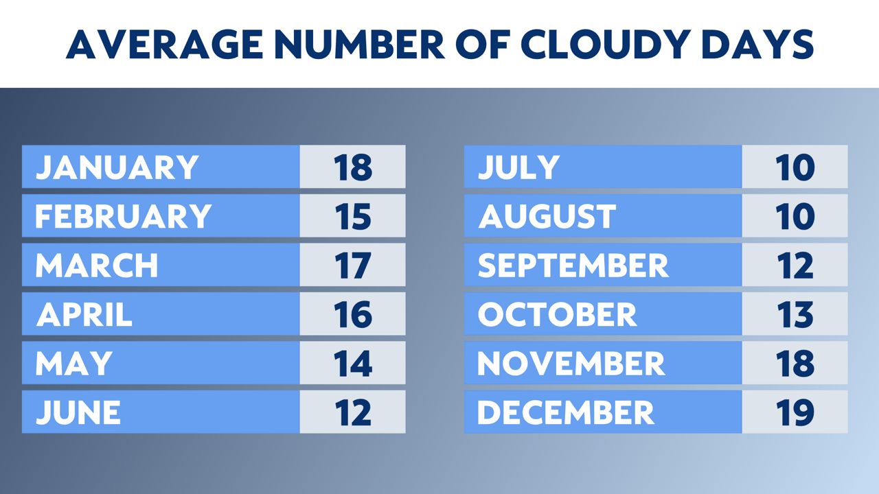
One other note: a large majority of the month was under cloudy skies. Many parts of the state did not have a full day of sunshine beyond April 3. Statistically, April is the fourth cloudiest month of the year.
MAY
As we hit May, the weather went in several directions. We spent the first week with highs in the 40s and 50s, but then we surged into the 80s and even touched 90 degrees in Madison on May 10. Record highs were tied in many spots a day later.
Severe weather also made a return with four tornadoes reported on May 9. Then we took a step back just after the middle of the month as highs returned to the 50s for a few days. We finished out May warm and humid as highs shot back up to the 80s.
JUNE
In what many expected to be a rather hot month, the summer warmth was missing to begin June. The first weekend of the month was the coolest first weekend of June in 13 years, as highs never made it out of the 60s. So much for the beaches and pools!
But just over a week later, that all changed. June 14 was the hottest day in 10 years across much of the state: highs touched 97 to 99 degrees in many spots. A day later, tornadoes tore across Wisconsin with 13 tornadoes hitting on June 15.
Then, on the official start of summer (June 21) Milwaukee touched 100 degrees for the first time since the summer of 2012.
We had multiple days with highs in the 90s, which is a tad unusual for us.
JULY
The heat and humidity stuck with us all month long. Severe weather made a return as well. Only one tornado this month: an EF-0 on July 23 near La Crosse.
There was plenty of rain throughout the month of July. This led to some Flash Flood Warnings around the middle of the month because of multiple rounds of heavy rainfall.
AUGUST
We began the month with another round of severe weather, however there were no tornadoes and very little damage. Highs in the 80s and 90s were common during the first week to 10 days, then we stayed in the 70s (but with high humidity) through most of the month.
The end of August brought yet another round of Severe Thunderstorm Warnings to parts of the state. Here again, little to no damage from those storms.
SEPTEMBER
Hot air made a return to kick off the month with highs in the 80s the first few days of September.
By the middle of the month, we got dumped on with rain. Some places picked up nearly eight inches of rainfall on Sept. 11 alone.
Much of the month was quiet for severe weather until the Sept. 20, when warnings developed in the southern half of the state. River Falls, Wis., just west of Eau Claire, saw baseball-sized hail on the same day.
We finished the month with a shot of cooler air, high temperatures in the 50s and the leaves changing colors on the trees, signaling fall was around the corner.
OCTOBER
Right on cue, fall hit us quickly this month as morning lows dropped into the 30s early in October. This helped to propel the leaves to change colors on many of the trees.
However, by the middle of the month, a surge of warm air returned and pushed highs in the upper 70s. This also led to a few bouts of severe weather and tornadoes. Seven tornadoes happened on the Oct. 12.
Just five days later, we had the first snowflakes of the season show up. Gile, Wis. saw 18 inches of snowfall while Madison picked up 0.2 inches, and Milwaukee had a trace.
Our coldest morning of the season happened on Oct. 19, but we weren’t done with the warm air yet. The upper 70s made one last return around Oct. 22 and we finished October with highs in the 50s.
NOVEMBER
Much like the previous month, we started out rather cool and wet. Once again, warm air made a return to the state with record highs on Nov. 10 as many areas hit the mid to upper 70s. Just three days later, highs barely made it above freezing. And by Nov. 15, snow had returned with many spots seeing two to four inches of snowfall.
It was a seasonal stretch of weather heading into Thanksgiving with highs in the 40s and 50s. We also ended up with some rare late-November sunshine for a few days in a row.
DECEMBER
We paid the price for all the November sunshine as much of the month ended up with a cloudy sky. Snow also became quite common this month, as most spots picked up snow on Dec. 9.
On Dec. 15, we began a 10 day stretch of snow across much of the state. Some in southern Wisconsin picked up 10 inches during that stretch. Meanwhile, northern Wisconsin saw totals topping two feet during that same span.
We hit the third week of the month with some bitter cold air, include subzero highs for some right before Christmas. Relentless wind slammed the state, sending wind chills to 30 degrees below zero across much of Wisconsin.
Now, in the final days of December, it appears mild air could return with highs near 50 possible by Dec. 29-30.
SEVERE WEATHER
Our first warning of the year happened on March 5 and our final severe warnings happened on Nov. 6.
Wisconsin had 28 tornadoes this year, down from the 41 we had in 2021. The first tornado was on March 5 and the last on Oct. 12.
We also had a prolonged period of heat and humidity during the summer, which pushed the heat index values well into the triple digits a few times. We also saw triple digit temperatures for the first time in 10 years.
TEMPERATURE EXTREMES
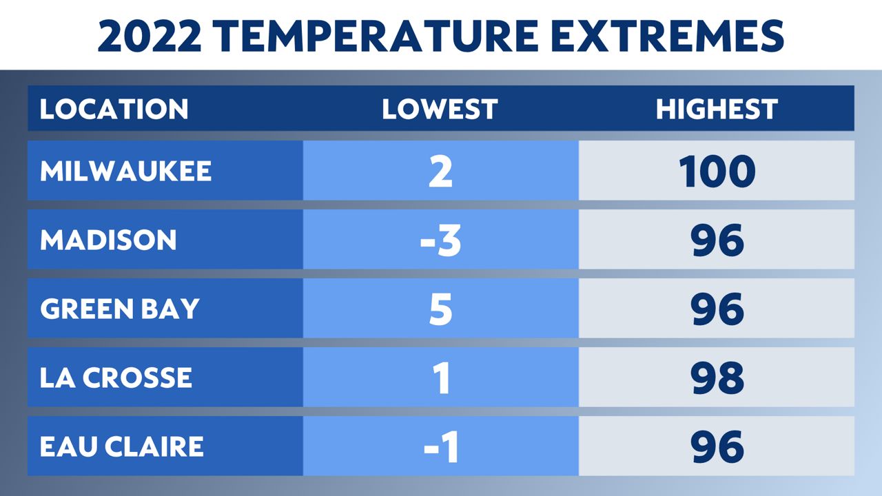
A look at the highest and lowest temperatures from the major reporting sites across the state this year:
So, the year of 2022 brought us the usual buffet of weather from start to finish. Thankfully, no lives were lost because of severe weather or extreme heat/cold. Let’s keep those trends going as we get set to enter the year 2023.
Our team of meteorologists dives deep into the science of weather and breaks down timely weather data and information. To view more weather and climate stories, check out our weather blogs section.


