Springtime tornadoes are nothing new for residents of the Midwest, Plains and even the South. It’s common, most cities and towns have tornado sirens and school children perform tornado drills, but is the U.S. seeing a higher number of tornadoes this year compared to the average?
In recent weeks, top stories have featured violent weather with tornadoes, damaging winds, large hail and flooding that injure people and infrastructures and even cause fatalities.
April 26 through May 9 was an active period for severe weather. At least one tornado report was submitted to the Storm Prediction Center per day.
Halfway through the month, the count stands at 234. How do these values compare to the average? Are we seeing more tornadoes than we used to, or is this just par for the course at this time of the year?
Dr. Harold Brooks, Senior Research Scientist with NOAA/National Severe Storms Laboratory in Norman Oklahoma, says this is the time of the year when the greatest number of tornadoes is observed.
Historically, May has produced the most violent twisters. Joplin, Missouri’s EF5 tornado occurred on May 22, 2011, and Moore, Oklahoma’s EF5, the last EF5 to touch down in the United States, happened on May 20, 2013.
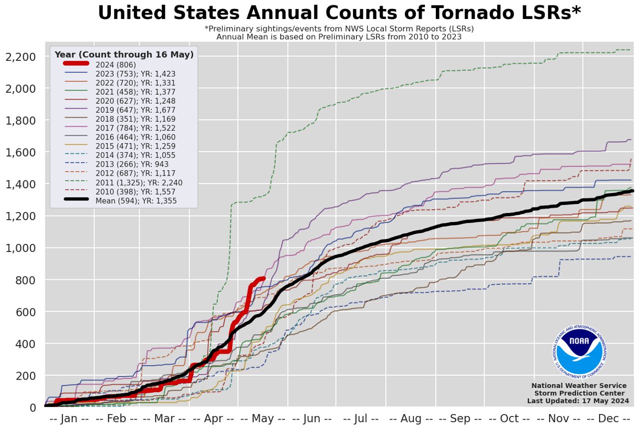
The tornado archives began in 1950, with averages compiled from 1991 to 2020. According to the Storm Prediction Center, preliminary data from Jan. 1 – May 16, lists 806 counts of tornadoes from local storm reports for the year so far.

The SPC analyzed April, noting 384 preliminary tornado reports, more than double the 1991-2020 April average (182). This was the highest count on record, since April 2011 and is second only to that same year.
Preliminary tornado reports are not the same as actual tornadoes.
Warning Coordination Meteorologist at the Storm Prediction Center, Matthew Elliot explains,
“In realtime, the National Weather Service collects what are called preliminary local storm reports. For tornadoes, these can be thought of as eyewitness reports of the tornado.”
Reports such as damage or video of a tornado are documented, showing the location of the damage and tornado. Each report will count as one tornado preliminary report.
However, he mentions that sometimes there may be multiple reports of the same tornado, especially longer-track ones, leading to overestimated tornado counts.
“Some preliminary reports end up not being tornadic after a ground survey has been completed (could be wind) while others are surveyed and entered into the official database but never have a preliminary local storm report issued (rarer but does happen).”
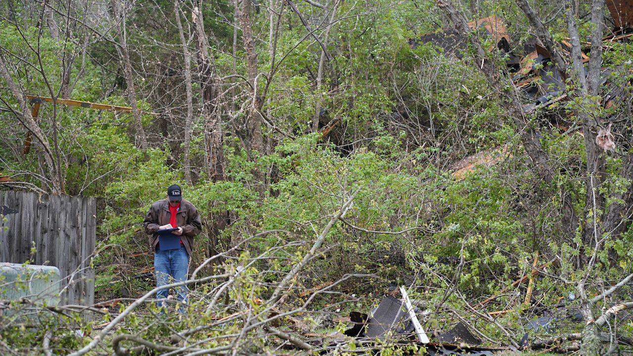
When information is relayed to the local National Weather Service offices about storm damage or tornadoes, NWS teams will complete a ground survey to verify these results, usually the following day. Meteorologist Alex Elmore with the National Weather Service in St. Louis explains the process of the storm survey teams.

“When storm damage occurs and we suspect it was possibly caused by a tornado or very strong straight-line winds, we will head first toward the location of the worst known damage,” he said.
The max wind speed can be estimated based on damage indicators, including trees, houses, out buildings, and the degree of damage such as missing shingles, partial collapse of the building, tree uprooted, etc., according to Elmore.
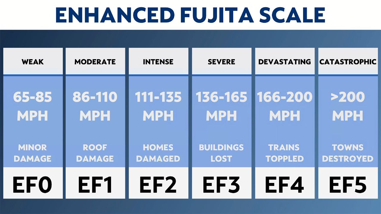
"If the damage was produced by a tornado, we assign it a rating on the Enhanced Fujita (EF) scale based on the wind speed," he said.

Sometimes the damage from a storm is not from a tornado but straight-line winds. Damage from straight-line winds will all be laying in the same direction, whereas tornado damage will comprise more circular damage.
They continue this process across the swath of damage until no more damage can be found. He says surveys for a single track can take several hours or upwards of an entire day, depending on the path length and degree of damage.
This process can be lengthy and take several months. Once investigations have been completed, the SPC publishes the final count. “Historically, for every 100 preliminary tornado reports, at least 65 tornadoes are confirmed,” says the SPC.
Tornado counts usually peak from March to June and then taper into the summer. The reason is because of the jet stream.
"One of the ingredients needed for thunderstorms to produce tornadoes is strong wind shear, and this is in part provided by the jet stream," Elmore says.
"During the summer, the jet stream shifts northward toward the U.S.-Canadian border, reducing the amount of wind shear we see locally during severe weather, which reduces the chance for tornadoes."
We may see more thunderstorms during the summer, but without wind shear, storms that become severe are more likely to produce hail and damaging winds.
Our team of meteorologists dives deep into the science of weather and breaks down timely weather data and information. To view more weather and climate stories, check out our weather blogs section.


