CINCINNATI — A number of streets in downtown Cincinnati and Covington, Ky. need to close during evening hours this weekend to make room for BLINK.
What You Need To Know
- A number of road closures and traffic restrictions are in place for BLINK
- Closures go into effect nightly from Thursday, Oct. 13 through Sunday, Oct. 16
- Metro and TANK are offering free bus rides to cut down on traffic congestion
- The Connector streetcar is operating extra cars each night of the festival
The pedestrian-friendly art and light festival is transforming 30 city blocks from Over-the-Rhine to Covington’s business district from Thursday, Oct. 13 through Sunday, Oct. 16. The festivities begin each night after dark.
BLINK is split into five different entertainment zones – Findlay Market, Over-the-Rhine, Downtown, The Banks and Covington.
There are more than 101 total art installations and various other pop-up displays set up throughout park spaces, alleyways and other public areas in each of those zones. For instance, there’s a night market at Court Street Plaza in the Downtown zone.
Event organizers expect a total weekend crowd of more than 1 million people over the course of the four-night festival.
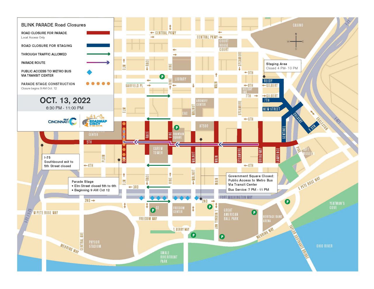
Most traffic restrictions go into effect during evening hours, beginning Thursday night for the BLINK Parade.
In Cincinnati, most closures are in effect from roughly 6:30-11 p.m. each night. There are a handful of closures for Thursday’s parade that start at 4 p.m. The parade starts at 7:30 p.m. and travels down Fifth Street.
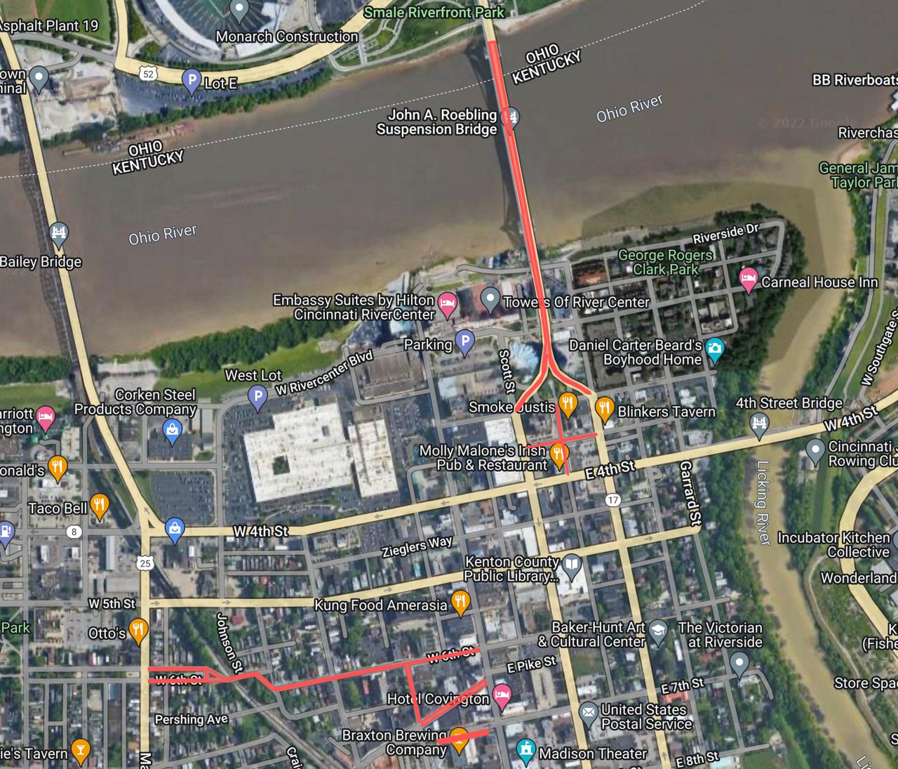
Most of Covington’s road closures are from 7-11 p.m. each night. The city’s Seventh Street “Alcove” — the parking area on the south side of the street stretching from Madison Avenue to Washington Street — is closed from 5:30-11:30 p.m. nightly during BLINK.
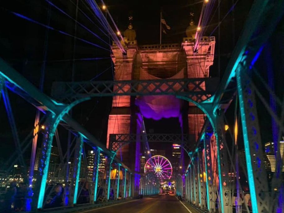
The Roebling Suspension Bridge is off limits to vehicles during BLINK. The pedestrian walkways on the bridge will remain open, but no one can walk in the roadway.
There are several public hospitality areas on both sides of the river that require continuous street closures throughout the event.
A full breakdown of scheduled closures is below.
The Cincinnati Police Department noted the potential need to shut down additional streets, at least temporarily, depending on traffic volumes each night.
Through traffic will be allowed with police help on several major streets while BLINK is under way all four nights of the festival.
Commuters and visitors are encouraged to carpool and use public transportation when possible because of expected traffic and limited parking.
Metro and TANK are offering free bus service after 6 p.m. during BLINK. They’ve set up park-and-ride options in Cincinnati and Northern Kentucky.
To help shuttle people between the zones in downtown Cincinnati, The Connector streetcar is adding extra streetcars for each night of BLINK.
CPD officers will ride ahead as an escort for the streetcar. All 18 station stops will be open. Station stops are wheelchair accessible with level boarding and accessible seating on every streetcar.
For safety reasons, the streetcar is only operating in OTR on Thursday.
Public and private parking garages and surface lots will remain open in areas surrounding the event location. CPD officers will maintain local access for residents, as well.
Government Square closes each night at 6 p.m. After that, bus users can catch their bus at the public entrances to the Transit Center along Second Street in downtown.
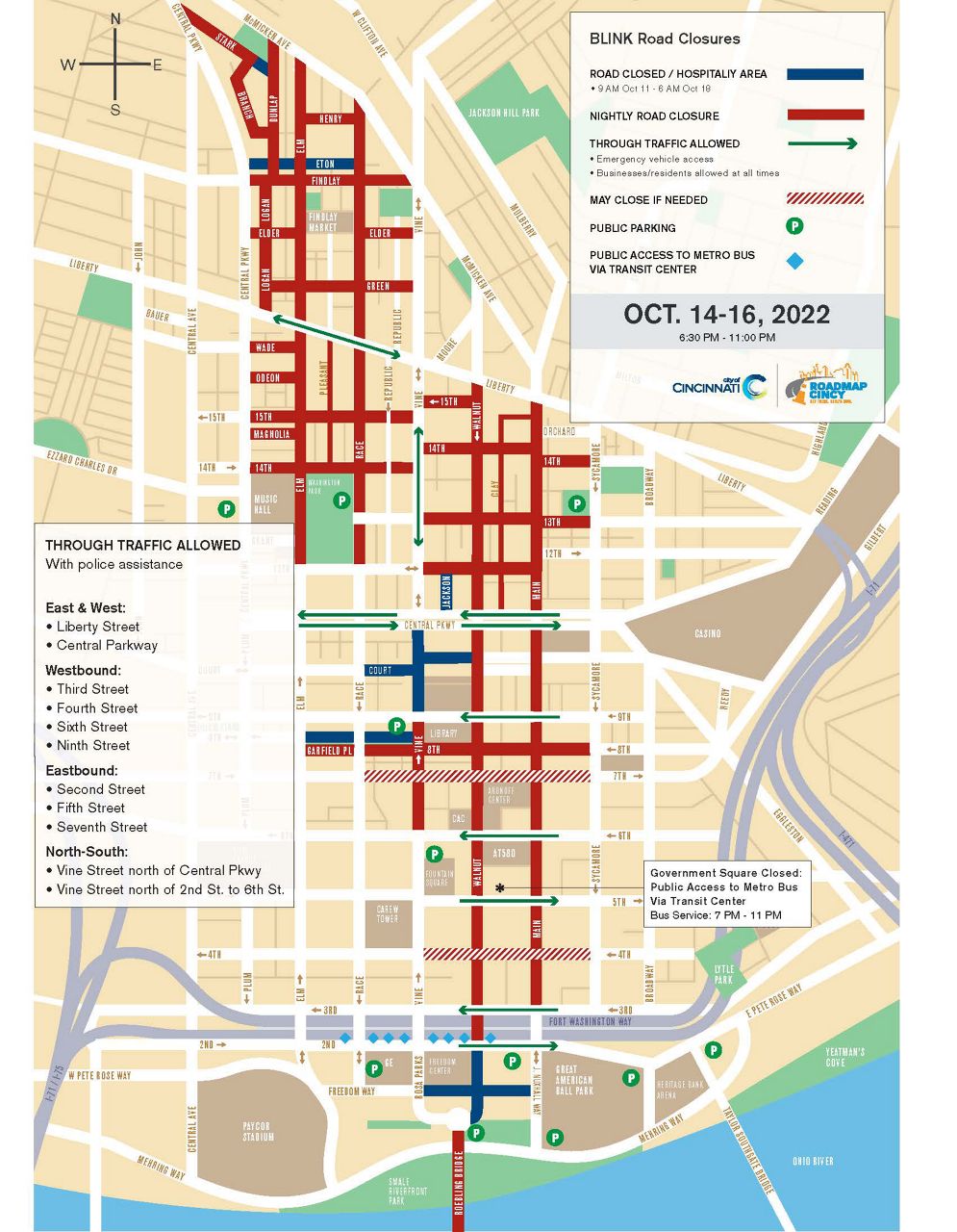
Cincinnati traffic closures
Over-the-Rhine: Findlay Market to Washington Park
- Elm Street: 12th Street north to McMicken Street
- Race Street: 12th Street north to McMicken Street
- Pleasant Street: Liberty Street north to 14th Street
- Dunlap Street: Findlay Street north to McMicken Street
- Elder and Findlay streets: Central Parkway east to Vine Street
- Green Street: Vine Street east to Logan Street
- Wade, Odeon and Magnolia streets: Central Parkway to Elm Street
- 15th Street: Walnut Street west to Central Parkway
- 14th Street: Central Parkway east to Sycamore Street
- 13th Street: Vine Street to Sycamore Street
- 12th Street: Vine Street to Main Street
Central Business District: Kroger store to The Banks
- Main Street: Third Street to Liberty Street
- Walnut Street: Second Street to Liberty Street
- Vine Street: Sixth Street to Central Parkway
- Eighth Street/Garfield Place: Elm Street to Sycamore Street
- Seventh Street: Race Street to Sycamore Street
- Fourth Street: Sycamore Street to Vine Street
- Roebling Bridge
Public hospitality areas
- Logan Street: Findlay Street to Elder Street
- Eton Alley: Elm Street to Race Street
- Jackson Street: Central Parkway to 12th Street
- Court Street: Race Street to Walnut Street
- Walnut Street: Ninth to Central Parkway
- W. Eighth Street: Vine Street to Elm Street
- Freedom Way: Rosa Parks Street to Joe Nuxhall Way
- Marian Spencer Way: Second Street to Ted Berry Way at Roebling Bridge
- Court Street: Third Street to Fourth Street (Covington)
- Park Place: Scott Street and Greenup Street (Covington)
Covington road closures
- Court Street: Third Street and Fourth Street (closed until 5 p.m. Monday, Oct. 17)
- Park Place between Scott and Greenup streets (Closed until 5 p.m., Monday Oct. 17)
- Roebling Bridge (no pedestrians on the roadway)
- West Pike Street: Madison Avenue and Washington Street
- Washington Street: W. Pike Street and Sixth Street
- Sixth Street: Madison Avenue and Main Street
- Seventh Street “Alcove”
BLINK Parade road closures
- Fifth Street: Broadway to Central Avenue
- No through traffic can take place one block north and one block south of each intersection along Fifth Street at Lawrence, Broadway, Sycamore, Main, Walnut, Vine, Race and Elm streets
- Sentinel Street: Fifth Street to Eggleston Avenue (closes at 4 p.m.)
- Reedy Street: Broadway to Eggleston Avenue (closes at 4 p.m.)
- Seventh Street: Broadway to Culvert Street (closes at 4 p.m.)
- New Street: Broadway ti Culvert Street (closes at 4 p.m.)
- Culvert Street between Reedy Street and E. Fifth Street (closes at 4 p.m.)
Through traffic allowed in Cincinnati
East-West
- Liberty Street
- Central Parkway
Westbound
- Third Street
- Fourth Street
- Sixth Street
- Ninth Street
Eastbound
- Second Street
- Fifth Street
- Seventh Street
North-South
- Vine Street north of Second Street to Sixth Street
- Vine Street north and south between Central Parkway and Liberty Street